
![]()
Some Files require
Adobe Reader
![]()
|
|||||||||||||||||||||||||||||||||||
|
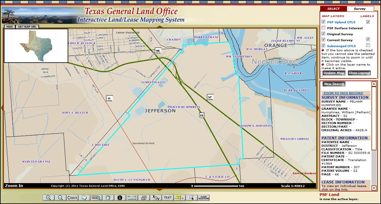
The following case study in genealogy fraud involves a land grant in Jefferson County Texas for Pelham Humphries...the same land where oil was found in 1901 at Spindletop. The land grant and the GIS Map are the only documentation of Pelham Humphries existence.
The Pelham Humphries story originally appeared in Heritage Quest Magazine, Volume 18, No. 4, Issue 100, Jul/Aug 2002 and was used with permission from James Petty who currently operates Heirlines Family History & Genealogy in Salt Lake City, UT. The photos and artwork in the article were used with permission from Leland Meitzler (the former editor of Heritage Quest Magazine) and current editor of Family Roots Publishing Company located in Bountiful, Utah. |
|||||||||||||||||||||||||||||||||||
|
Striking It Rich: |
|||||||||||||||||||||||||||||||||||
|
Here is a GIS map from the Texas Government Land Office of the original land grant
given to Pelham Humphries:
The following is the information found on the Texas Government Land Office
page for Pelham aka William Humphries. I have included the PDF files found on the GLO here for your convenience. Texas General Land Office
|
|
|
This file needs professional conservation work. Follow me to be a part of Save Texas History ! |

|
County: |
Jefferson |
|
Abstract Number: |
32 |
|
District/Class: |
Title |
|
File Number: |
SC 000055:8 |
|
Original Grantee: |
Humphries, William [Pelham] |
|
Patentee: |
|
|
Title Date: |
14 Feb 1835 |
|
Patent Date: |
|
|
Patent No: |
307 |
|
Patent Vol: |
22 |
|
Certificate: |
Translation #1964 |
|
Part Section: |
|
|
Survey/Blk/Tsp: |
|
|
Acres: |
4428.4 |
|
Adj Acres: |
|
|
Remarks: |
Marsh on the west bank of the Neches; joins Veatch. See 393 Federal Reporter, 2nd Series, (1968), pp. 67-75. Also Civil Action B-89-00423-CA in the U.S. District Court for the Eastern District of Texas, Beaumont Division. |
|
View the land grant PDF |
| Home | |Top of Page |
Vote Montgomery County TXGenWeb County of the Month
|
Montgomery County Texas Banner graphics were designed by and remain the property of Jean Huot Smoorenburg. If you are being charged to view/use any of this information or have questions or comments, please contact Jane Keppler. |
|
|
|
Copyright © 1997- present
- 2016 by
Jane Keppler.
This
information may be used by individuals for their own personal use,
libraries and genealogical societies. Commercial use of this information
is strictly prohibited without prior written
permission
from
Jane Keppler.
If material is copied, this copyright notice must appear with the
information and please email me and let me know.
Neither the Site Coordinators nor
the volunteers assume any responsibility for the information or material
given by the contributors or for errors of fact or judgment in material
that is published at this website. |
|
Page Modified: 18 October 2016 |