

Texas
Welcome!
County Coordinator is Jane Keppler.
If you have any questions or would like to submit information for Robertson County, please email
one of the above.
We do not live in Robertson County so we cannot do research but might steer you in the right direction.
|
||
| site search by freefind |
|
TXGenWeb Robertson County Books & Master's Theses |
|
G H O S T L Y H A U N T S C O L L E C T I O N |
|
Heard voices in the
shadows speaking
foreign languages?
|
Are these the sights and sounds of bygone eras, the products of fertile imaginations, or Robertson County's ghosts?
To help website visitors explore Robertson County's ghostly past, this new collection will record information about Robertson
County's "Booger", MOJO, immigrant ghosts, ghost camp, ghost spa/resort, ghost railroads & mule train, ghost bridge,
ghost road, ghost park, ghost towns & vanished communities, and other unusual historic places of interest.
Robertson County's Booger
| Booger County |
Information
on how Robertson County may have acquired this rather
unfortunate nickname is at Booger County.
|
||||
| MOJO |
MOJO (not
his real name), was a young man from the Bryan, Texas area, who early
in the 20th century supposedly fell off a train and was killed at Mud
Creek near Calvert. His family was unable to pay the expenses
for having his body embalmed and prepared for burial.
In
a bizarre twist of fate, MOJO's
body was kept at a succession of Calvert funeral homes for eight
decades. Only recently (on 6.19.2002) was he laid to rest
at Robertson County's Chapel Hill Cemetery.
|
||||
| Different Languages Immigrant Ghosts |
Ever
think you're hearing Polish spoken when you're in Bremond, German
when you're in New Baden, Italian when you're in Mumford, or detect an
Irish accent when you're in Benchley? You may be hearing
whispers from the ghosts of settlers past. Check out
Polish Collection,
New
Baden Collection, & Irish
of Staggers Point.
|
||||
|
Camp Hearne
Ghost Camp
|
|
||||
| Wootan Wells Ghost Spa/Resort |
|
||||
| Calvert Ghost Railroad Ghost Railroads & Mule Train | The Calvert Ghost Railroad was a spur of the Calvert, Waco, & Brazos Valley Railroad that was built by the end of 1900. After operating for almost 3 1/2 decades, the three-mile route was abandoned in 1934. This ghost railroad appears on two Calvert fire insurance maps. This route (from the river bottom road up behind the Calvert County Club) is identified as the "old railroad grade" on Calvert Map. It connected in a "Y" at the old CW&BV Railroad tracks. | ||||
| Bremond Ghost Railroad | The Bremond Ghost Railroad was a route of the Houston & Texas Central Railway that connected Bremond with Marlin and Waco. After operating for roughly a century, the Bremond to Waco route was abandoned in 1967. This route is identified as the "old railroad grade". | ||||
| Sutton Ghost Railroad | The Sutton Ghost Railroad was outside of Sutton (between Benchley & Hearne) on the Houston & Texas Central Railway. It consisted of a "Y" connection at the Houston & Texas Central Railway tracks and extended about a mile into what is now a farmer's pasture. | ||||
|
Wootan Wells Ghost Mule Train
|
|
||||
|
Iron Pillars
Marking West End Of Old Brazos River Bridge
|
About
two miles west of Mumford, there's
a Texas Historic Marker that reads: "An 1895
engineering victory - longest Brazos Bridge in that era - spanning
heavy flow
below ford of 'Little River' [San Andres] with 'Big Brazos'. This
bridge stood
where immemorial Indian trails crossed the river. Later these paths
became part
of the El Camino Real [The King's Highway]. About a mile downstream, in
1830,
Fort Tenoxtitlan was established. In 1855, Jesse Mumford [founder of
Mumford]
operated a ferry at the trail crossing. Authorized by Commissioners
Court of
Robertson County, this landmark iron bridge served until removed by a
flood in
1899."
Directions:
About 2 miles west of Mumford.
|
||||
|
El Camino
Real, King's Highway, Old San Antonio Road, Old San Antonio & Nacogdoches Trail, or OSR
|
Texas
Historic Marker one mile east of Hwy 6 at Benchley on Old San
Antonio Road reads as follows: "A trail of adventure,
opportunity, hardships, and freedom, over which history stalked into
Texas. To the Spanish, El Camino Real was a road traveled for the King
- to colonize, christianize, seek adventure, and look for riches. This
road became the most famous. Its many parts were made, discovered, or
known hundreds of years before 1691, when Domingo Teran De Los Rios,
first Texas governor, joined and marked the different trails for the
King. It was the route from Monclavia [crossing the Rio Grande near
Eagle Pass] to the missions of East Texas. Probably its trailblazers
were buffalo and Indians, or Aztecs on trading expeditions. It was also
possibly traveled, described, and changed in part by French explorer
LaSalle; by Alonso de Leon & Father Damien Massanet planting
missions in East Texas; and by the French nobleman St. Denis seeking
trade along the Rio Grande. As the years wore on, it was traveled in
1820 by Moses Austin, as well as by thousands of settlers who followed
him. San Augustine Nacogdoches and San Antonio were its principal
cities and inns sprang up along the way. Soldiers and supply trains
used it during the Texas Revolution, Mexican War, & Civil War.
It is still followed in part by this highway."
The
Handbook of Texas Online also
has information at
Old
San Antonio Road. Directions: Texas Historic Marker is 1 mile east
of Hwy 6 at Benchley on Old San Antonio Road.
|
||||
|
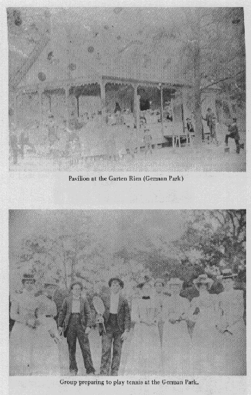
Calvert's Garten Rhien Park
|
According to John Walter Baker on p. 534 of his book History of Robertson County: "The German families in Calvert had 'The Garten Rhien,' a ten-acre park complete with tennis court, pavilion, horseshoe throwing courts, card tables, and a beer barrel platform on the lawn. They met every Sunday to eat, drink, and hear the music of their fine band, directed by Mr. Jietsch. They had maple lanes for playing tenpins that were built by the Lang brothers, and for their amusement they also had their own Negro band." So, if you hear voices speaking in German in the shadows on a Sunday afternoon in Calvert, these may be coming from the former location of Calvert's Garten Rhien Park. Directions: Does anybody know where this park was? If so, please contact Jane Keppler. | ||||
| Box Quarter/GHOST TOWNS & VANISHED COMMUNITIES | Have you ever heard of Box Quarter, Robertson County, Texas? The Handbook of Texas Online has an article about it at Box Quarter. Directions: Does anybody know where Box Quarter actually was? If so, please contact Jane Keppler. | ||||
| Englewood/GHOST TOWNS & VANISHED COMMUNITIES |
|
||||
| Fort Tenoxtitlan/GHOST TOWNS & VANISHED COMMUNITIES | Have you ever heard of Fort Tenoxtitlan, nearby in Burleson County, Texas? Fort Tenoxtitan has two Texas Historic Markers. Marker #1 reads: "2000 feet south, site of Fort Tenoxtitlan established by the Mexican government in July, 1830, in an attempt to stem Anglo-American settlement. Named in honor of the Aztec capital, now Mexico City. Abandoned by Mexican troops in 1832. In the town which grew up after 1834 many prominent Texans lived. The place passed from the map after 1860" Marker #2 reads: "Founded by Mexico as a bulwark against Anglo-American immigration, this fort and its nearby city were twice proposed for the capital of Texas. Alarmed by the influx of Anglo settlers into Texas, Mexico in 1830 sought to erect a line of forts to keep out the intruders. The ancient Aztec name for Mexico City [originally pronounced "Tex-ox-teet-lan"] was given this site; it means "prickly pear place". So hopeful of the fort's success was the military commandant of the region that he envisioned it as the capital of Texas. But Anglo immigration did not cease. Instead it thrived on the friendship of the local soldiers and incoming pioneers. The colonizer Sterling Clack Robertson introduced scores of settlers. In 1832 the soldiers were withdrawn and the fort finally defaulted to the Anglos. Subsequently it was a supply center and mustering point for expeditions against the Indians. During its brief life many Texas patriots lived here, including 5 signers of the Texas Declaration of Independence, a martyr of the Alamo siege, and 7 soldiers of the Battle of San Jacinto. Tenoxtitlan was again suggested for the capital of Texas during the Republic, but Austin won out. In 1841, after many Indian raids, the site was abandoned." The Handbook of Texas Online has an article at Fort Tenoxtitlan. Directions: From Caldwell, take SH 21 E about 6 miles to FM 1362, go N about 8 miles to CR 338, go E about 1.5 miles to double gate - marker is about 1/2 mile S across creek. | ||||
|
Hayes/GHOST TOWNS &
VANISHED COMMUNITIES
|
Have you ever heard of Hayes, Robertson County, Texas? The Handbook of Texas Online has an article about it at Boone Prairie/Hayes. According to Post Offices Of Robertson County, Hayes had its own post office from 5.24.1880 - June 30, 1906. | ||||
| Lake, Lake Station, Kirkpatrickville, or Acorn/GHOST TOWNS & VANISHED COMMUNITIES | Have you ever heard of Lake, Lake Station, Kirkpatrickville, or Acorn, Robertson County, Texas? The Handbook of Texas Online has an article about different names for this same town at Easterly & Lake. According to Post Offices Of Robertson County, the following post offices existed: Lake (3.4.1872 - 12.31.1903), Lake Station (11.23.1876 - 12.16.1878), Kirkpatrickville (2.5.1879 - 4.1.1879), Acorn (5.17.1881 - 3.24.1890), & Easterly (6.6.1894 - 1.12.1929). | ||||
| Mount Vernon/GHOST TOWNS & VANISHED COMMUNITIES | This ghost town is featured in Ghost Towns of Robertson County at Mount Vernon. The Mount Vernon Cemetery is about all that is left of this community. Directions: 6 miles east of Calvert on the Calvert to Owensville highway. | ||||
| Nashville-On-The-Brazos/GHOST TOWNS & VANISHED COMMUNITIES | Have you ever heard of Nashville, nearby in Milam County, Texas? Nashville's Texas Historic Marker reads: "Surveyed in the fall of 1835 as the capital of Robertson's colony. Named for Nashville, Tennessee where Sterling Clack Robertson and many of his colonists had formerly lived. Seat of justice Milam municipality, 1836; Milam County, 1837. First home in Texas of George C. Childress, chairman of the committee which drafted the Texas Declaration of Independence." The Handbook of Texas Online also has information at Nashville-On-The-Brazos. Directions: Just across the Brazos River Bridge on US 79 at road side pull-off on the west side of highway. | ||||
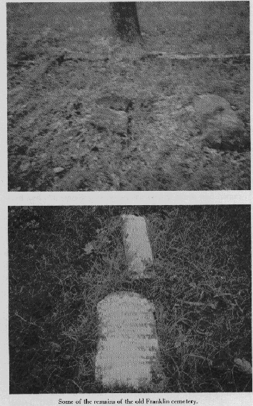
| Old Franklin/GHOST TOWNS & VANISHED COMMUNITIES |
|
||||
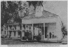
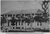
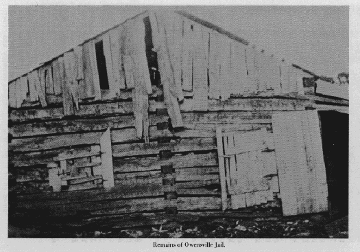
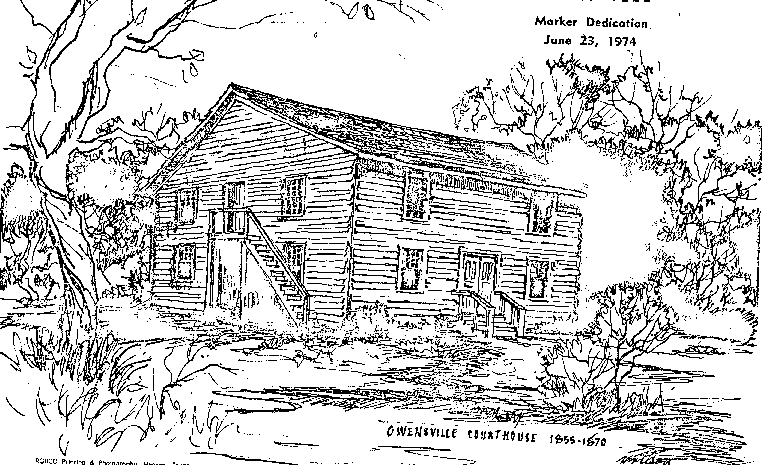 Owensville/GHOST TOWNS & VANISHED COMMUNITIES
|
|
||||
| Port Sullivan/GHOST TOWNS & VANISHED COMMUNITIES | All that remains of this once bustling trade center just across the Brazos River in Milam County is its historic cemetery. John Martin Brockman has recorded this ghost town's history at Port Sullivan. Port Sullivan's Texas Historic Marker reads: "Early important trade and educational center. Established by Augustus W. Sullivan in 1835. River navigation extended to this point for many years. The Austin-East Texas and the Houston-Waco roads crossed here. On this spot was located Port Sullivan College. Established in the early fifties. Incorporated December 16, 1863. Destroyed by fire in 1878." The Handbook of Texas Online also has information at Port Sullivan as well as at Fort Sullivan. Directions: Located off of FM 485 / CR 260, 1 mi. to county road 259 approx. 1.3 mi. on south side of dirt road. | ||||
| Staggers Point/GHOST TOWNS & VANISHED COMMUNITIES |
This
ghost town is featured in Ghost
Towns of Robertson County at
Staggers Point.
The Staggers Point Texas Historic Marker reads: "Earliest large community in Robertson's colony. Settled by Irishmen who came to America in 1821; lived in South Carolina and then in Alabama; and in 1829 sent west an emissary, Robert Henry, to find a permanent location. In 1833, their ox-wagon train arrived, and log cabins were built. By 1836, kinsmen had joined early arrivals to strengthen settlement. Community name, meaning "Strivers' Point" in dialect, was probably given for rugged zeal of settlers in face of hardships. James Dunn built a fort, to give neighborhood a refuge during Indian raids. In War for Independence, 1835-36, Staggers Point men fought in major actions, including the April 21, 1836, Battle of San Jacinto, which freed Texas from Mexico. In 1830s and 40s, the Irish were compelled to keep up their defenses against the Indians. Women as well as men earned respect for skill with "long guns." In time their village had a church, stores, cotton gin, race track, and taverns, and was invaded by gamblers and ruffians drawn to the races. Until the settlers subdued the lawless, duels and gunplay were common. This remained a progressive community until 1868, when Houston & Texas Central Railway bypassed it, and business waned. Descendants still honor the settlers. Original settlers: William Henry, Mary F. Henry Dixon, James M. Dixon, Ann McMillan, Henry & Sarah Fullerton, Robert & Elizabeth Henry, George H. Fullerton, John R. & Sarah Peyton, Jimnive Henry Rice, William Fullerton, Hugh & Elizabeth Henry, James A. Henry, Bradford & Mary Henry Seale, Columbus & Elizabeth Henry Seale, James & Isabella Dunn" The Handbook of Texas Online also has information at Benchley/Staggers Point. Directions: 1 mile east of Hwy 6 at Benchley on Old San Antonio Road. |
||||
| Sterling/GHOST TOWNS & VANISHED COMMUNITIES |
This
ghost town is featured in Ghost
Towns of Robertson County at
Sterling.
The Texas Historic Marker at the Sterling Cemetery reads: "Burial place of some 400 Texas pioneers and descendants. On land granted [1835] to A. J. Webb; bought in 1850 by Judge Robert Calvert, a civic leader in Sterling, a town named for empresario Sterling C. Robertson. Calvert dedicated 11.1-acre cemetery and built adjacent Cumberland Presbyterian Church of his own plantation timber. In 1867, Judge Calvert died and was buried near cemetery gate. The church building was moved by oxen to new town of Calvert [2 mi. E]. In 1868, his wife, Mary Keesee Calvert, and their three daughters deeded cemetery site to the Cumberland Presbyterians." The Handbook of Texas Online also has information at Sterling. Burial information is at Sterling Cemetery. Directions: Two miles west of Calvert on FM 979 to CR 116.
|


*
Did you find the Robertson County TXGenWeb
Project helpful or useful?
You can vote for it or another TXGenWeb county for
County of the Month
You can vote for it or another TXGenWeb county for
County of the Month

Page Modified: 25 March 2025

Copyright @ 2014-present by