|
|
|
Montgomery County created this week in 1837
By Robin Montgomery
|
|
|
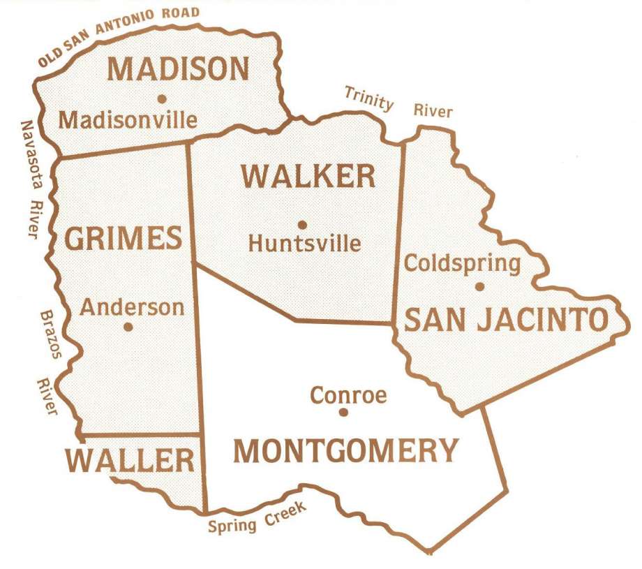
Map from the Montgomery County Historical Commission
Original county boundaries of Montgomery County included Grimes,
Walker, San Jacinto and
a portion of Madison and Walker counties. Montgomery County was
formed on Dec. 14,1837
|
|
Roots of our country reach to the Independence of Mexico from Spain
in 1821. By 1824, Mexican Texas allied with the state of Coahuila
whose capital was in Saltillo. From 1824 until 1831 Texas consisted
of one department, headquartered in San Antonio. In 1831 it was
added to the Department of Nacogdoches while 1834 witnessed the
birth of the Department of the Brazos, with its capital at San
Felipe de Austin. |
|
The Department of the Brazos stretched West to East from the Lavaca
River to the watershed between the San Jacinto and Trinity Rivers
and South to North from the Gulf to the Red River. By the time of
the Independence Convention at Washington on the Brazos in March
1836, stretched over the three departments were 23 municipalities,
entities similar to Anglo counties. Indeed, at that convention, on
March 17, the Texans designated all 23 municipalities as counties
One of the municipalities in the Department of the Brazos,
established in 1828, was Austin Municipality. Originally that
municipality reached from the Lavaca to the San Jacinto River West
to East while ranging from the Gulf to the San Antonio Road South to
North. By 1833, Austin Municipality had expanded, incorporating such
communities as Bastrop, Matagorda and Harrisburg. |
|
ustin Municipality eventually broke up into 15 smaller
municipalities. One of these, formed in 1835, was Washington
Municipality, headquartered at Washington on the Brazos. When the
Constitutional Convention declared all municipalities as counties,
Washington Municipality became Washington County occupying both
sides of the Brazos River. Then began the breakup of this great
county. On the West, the county yielded land for the new counties of
Brazos, Washington, Burleson and Lee counties. |
|
Meanwhile, settlers on the east side of the Brazos were frustrated
with traveling the distance to Washington for official county
business in an atmosphere of mosquitoes. Consequently, several
petitions from the settlers led on Dec. 14 to the birth of the new
county of Montgomery. This was the third county, after Houston and
Fannin, which the new Republic of Texas created. |
|
The Texas Legislature designated the borders of the new county to
include “all that part of the County of Washington lying east of the
Brazos, and southeast of the Navasota Rivers.” This made clear the
western border while the northern border was clearly marked as the
San Antonio Road. As heir of Washington Municipality, the southern
border centered on Lake Creek. However, by 1840 it reached to Spring
Creek. |
|
The volatile search for an eastern border holds special interest to
citizens of Conroe. On Dec. 18, 1837 it was ruled that Liberty
County would reach only nine miles west of the Trinity. Only then
was it clear that the future Conroe and its immediate environs would
rest exclusively within Montgomery County for Liberty Municipality
had stretched to the San Jacinto. Also, while part of the eastern
boundary reached the Trinity, for a short time the area of future
Conroe occupied an earlier version of Madison County with a Hamilton
County above and a Spring Creek County below just above a bit of
Harrisburg County. |
|
To further complicate matters, three other colonial efforts centered
on the San Jacinto as their western border. One of these was the
aborted colony of Hayden Edwards which lost its bearings in the
ill-fated Fredonian Rebellion. Another was that of Joseph Vehlein
which fused into a coalition with Lorenzo de Zavala and David G.
Burnet. By 1830, this group had assigned its holdings to the
Galveston Bay and Texas Land Company, headquartered in New York,
whose exotic and myriad machinations meandered through and beyond
the era of the Republic of Texas. |
|
The third colonization effort whose legal jurisdiction spread
westward to the San Jacinto was a colony in the Atascocita District.
The colony was heir of a Spanish Fort and military outpost
established in the mid-18th Century to guard against French
incursion into the area of the Trinity River. From 1826-31 settlers
from the US exercised authority over the Atascocita mandate area
stretching from the San Jacinto to the Sabine and from the Gulf to
Nacogdoches. Later this area became Liberty Municipality which, in
turn, became Liberty County. |
|
As things settled, in 1846 carved out of Montgomery County were
Grimes and Walker Counties to be followed in 1853 by a portion of
later Madison County and in 1870 by a part of San Jacinto County.
Finally, in 1873 Montgomery County gave way to a small section of
Waller County. |
|
Amazing are the crosscurrents of history that led to Montgomery
County as we know it. Later, an article addressing the various
theories on the naming of the county and an aborted effort to name
it Travis. |
|
Robin Montgomery is a native of Montgomery County, a historian,
professor, author and contributing columnist for The Courier. |
| |
| |
|
The
Courier December 15, 2019 |
| |
|
|
Home
|
Top of
Page |
Montgomery County Geographic History |
|
| |
|
|
| |
|
 Vote
Montgomery County
TXGenWeb County of the
Month Vote
Montgomery County
TXGenWeb County of the
Month
Montgomery County Texas Banner graphics were designed by and remain
the property of
Jean Huot Smoorenburg. You
cannot use this banner without my written approval.
Copyright © 1997 -
2019 by
Jane Keppler.
This
information may be used by individuals for their own personal use,
libraries and genealogical societies. Commercial use of this
information is strictly prohibited without prior written
permission
from
Jane Keppler. If material is
copied, this copyright notice must appear with the information and
please email me and let me know.
Neither the Site Coordinators nor
the volunteers assume any responsibility for the information or
material given by the contributors or for errors of fact or judgment
in material that is published at this website.
If you are being charged to view/use any of this information or have
questions or comments, please contact
Jane Keppler.
|
|
|
|
|
|
Page Modified:
24 March 2025 |
|