

Settlement in the Forks of Mill Creek
Pages 3 - 13
Settlement in the Forks of Mill Creek
A History of the Nelsonville Area
Austin County, Texas
By James V. Woodrick
February,
2005
A note from the author ...
My inspiration in researching
the history of the Nelsonville area can be directly attributed to
John T. Kroulik, PhD, son of Nelsonville physician John Kroulik. He
willingly shared his lifelong passion in genealogy and in preserving
the record of Texas settlement by Czech immigrants, as well as his
personal childhood memories of the area and its people. His gentle
nudging provided encouragement for me to proceed, and through him I
was able to interview several individuals who provided invaluable
information and other materials for this research effort. Included
among these were Lydia Stalmach Maresh, Hettie (Mrs. Paul) Albert,
Miss Rosalie Lesikar and Mrs. Gracie Jezek Hinze. My mother-in-law
Sadie Kroulik Bravenec, and Edwin and Eslie Maresh Krause were
always eager to share their knowledge of the area’s history. John
Dorroh provided information on his ancestor Flake family, as did
Fred Burns on his family. O. B. Shelburne provided a wealth of
information on the area and his ancestors, including a photo of the
first dwelling built in the forks of Mill Creek and an 1895
newspaper article detailing the then-thirty year history of
Nelsonville. Theda Conner provided information on her husband’s
great-great grandfather E. C. Williamson. Ray Stepan and Jerry
Krampota provided information about their ancestors. Photos from the
late 1800’s to the 1920’s of people and places in and around
Nelsonville were obtained from a number of people whose parents or
grandparents lived in the area.
I hope that this
project will continue to grow as more historical and family
information becomes available. If any reader has pertinent
information and is willing to share it with others, please contact
me and I will include it in future updates.
James Victor
Woodrick jwoodrick@sbcglohbal.net
2700 Maria Anna
Austin,
Texas 78703
(512) 454 – 0800
Nelsonville, Texas, is located in Austin County approximately eight miles west of the county seat of Bellville, on the oak-forested ridge between the east and west forks of Mill Creek. Communities nearby are Industry eight miles west, Oak Hill approximately two miles east and Bleiberville about four miles northwest of Nelsonville. Scranton Grove was an early community in the area on the East Fork of Mill Creek between Nelsonville and Bleiblerville. New Bremen and Travis were early communities nearby but across (outside) of the east and west forks of Mill Creek. The land area comprising the extended Nelsonville community begins at the juncture of the East and West Forks of Mill Creek and extends up the forks approximately half way to the town of Industry. /p>
This history of the settlement of the land around Nelsonville focuses primarily on the lower portion of the land between the forks of Mill Creek, including portions of the Four League Grant to Stephen F. Austin and the adjacent George Grimes and Benjamin Eaton grants, comprising about 25 square miles. Further upstream within the forks of Mill Creek the settlers focused on Industry, Welcome and Wesley as the major community centers. Outside of the East Fork the focus was on the early community of Travis, later on the railroad-established town of Kenney. Outside of the West Fork the settlers in the New Bremen area looked to New Ulm and Cat Spring as the major community centers. Bellville was the dominant town to the east.
This account is primarily of the century from the first appearance of permanent settlers in 1838 to the peak of the strong Nelsonville community focus before World War II. The advent of the automobile, and in particular the opening of the paved highway in 1929 to the much larger town of Bellville, expanded the rural community's horizons. After 1930, the town of Nelsonville gradually declined as a social and commercial center in the region.
Most of the early settlers were farmers of British origin from the southern United States, and their slaves of African origin. After the close of the Civil War the economy of the region changed dramatically with the ending of the plantation system of agriculture. Many of the early white settlers left in the two decades after the Civil war but their former slaves, now freedmen, remained longer as farmers and laborers in the area. Continental European immigrants began to occupy the land after the Civil War, first primarily Germans but later almost exclusively Czechs. By the turn of the century, the population was predominately of Czech ancestry.
The 1880 Census for Precinct 7 of Austin County included the area in the lower forks of Mill Creek, and is summarized as follows:
- 1520 individuals in 285 family groupings
- Ethnicity of the “Heads of Household”
- 32% Anglo, most from older southern United States
- 31% Czech, most first generation immigrants
- 18% African American
- 15% German
- 4% Other European countries and northern United States
The 1900 Census, as enumerated by J. A. Malechek between June 1 and June 20, 1900, in the "Nelsonville" precinct, is summarized as follows:
- 1396 individuals comprising 257 family groups
- Origin of the heads of household:
- 50% Born in Bohemia
- 10% Born in Texas, father born Bohemia
- 15% Born in Germany
- 5% Born in Texas, father born Germany
- 15% Born in Texas, African ancestry
- 5% Born in southern United States, British ancestry
The Nelsonville area represented the largest concentration of Czech - speaking people in Austin County, and a spring-board for Czech migration to other parts of Texas. The first Czech immigrants to settle in Texas had arrived in Austin County in 1852, settling among the Germans in the New Ulm – Industry area. In the 1900 Census tabulation the name Bohemia is used to designate peoples from all Czech-speaking lands including Cechy (also commonly referred to as Bohemia), Moravia, Slovakia and Silesia. Austria is also commonly shown as the country of origin for Czech Texans in immigration and naturalization documents and the U. S. Census, as at that time the Czech lands were part of the Habsburg (Austrian) Empire. Austin and Fayette Counties were the primary areas of settlement of Czech immigrants before and immediately after the Civil War. Beginning around 1900, both new Czech immigrants and the children of the early settlers who needed new farms for the expanding number of families began to settle in other parts of Texas.
History of the Area Prior to Settlement
The land was originally claimed by Spain in the early 1500's, and remained largely unexplored by the Spanish through the early 1700's. Bands of Native Americans during this early period were the Mayeye and Yojuan (Tonkawans) living primarily to the north and west, Orcoquizas, Bidais and Hasiani tribes to the east/northeast, with Coco and Arkokisa (Karankawan) toward the coast. Tonkawans and Karankawans were primarily hunting and gathering societies living in much the same manner as they had for several thousand years. The Hasiani tribes lived in relatively permanent villages in the East Texas pine forests where they practiced agriculture, occasionally appearing in areas west of their primary territory. The Orcoquizas lived in relatively fixed villages growing some maise but living to a large extent on a fish diet supplemented by native fruits, nuts and game. At the time of Spanish contact, the Austin County area was between the major indigenous population centers, probably being crossed by traders and migrating groups from all directions. The two closest significant Indian villages mentioned in early Spanish records are near La Grange (a trade center frequented by several tribes from east and west Texas as well as two local tribes named Sana and Tohaha) and the Orcoquiza village of chief El Gordo ten miles east of the Brazos River on the headwaters of Cypress Creek.
The first European in the Mill Creek area could have been the Spaniard Cabeza de Vaca during his several year captivity with the Karankawa Indians in the Galveston area beginning in 1528. His memoirs indicate that he was involved in inland trade with other tribes during this period. The region between the Colorado and Brazos Rivers would have been a logical trade area from the coastal region, and Mill Creek is a major tributary of the Brazos.
In 1685, Rene Robert Cavelier, Sieur de la Salle, established a French colony on Garcitas Creek above Lavaca Bay in modern Victoria County. He made forays in 1686 and 1687 to the northeast in search of the Mississippi River in which he passed through the upper Mill Creek vicinity. Documentation of LaSalle's trips are not sufficiently detailed to precisely locate the routes that he traveled, but historians generally agree that these two trips went through or near the northern part of present-day Austin County. The Indian trail that became the Spanish La Bahia road seems a likely route.
Later, in the mid-1700's, the Spanish road between the La Bahia mission complex and Nacogdoches, the East Texas mission complex and Los Adaes (the mission/presidio near Natchitoches, Louisiana) passed through this area. The La Bahia presidio and mission were originally established in 1722 on Garcitas Creek in modern Victoria County, moved in 1726 to the Guadalupe River several miles north of Victoria and again moved to Goliad in 1749. Maps compiled by Steven F. Austin in 1829 and 1836 indicates the La Bahia road (also known as the “lower” Camino Real) went across the upper forks of Mill Creek near Shelby. Early land records clearly indicate that by 1840 the La Bahia road crossed the Colorado at La Grange and roughly followed the route of Hwy 237 through Round Top and Burton on to a crossing of the Brazos River at the town of Washington, just below the juncture of the Navasota River. The Spanish first used this Indian trading trail in expeditions to East Texas in 1690, 1692, 1693 and 1718. During most of the second half of the eighteenth century there was relatively frequent travel by the Spaniards between San Antonio, La Bahia and the East Texas Missions on the La Bahia road, and even more frequent use after the founding of Steven F. Austin’s colony in the 1820’s.
An Indian trading trail and Spanish road used at least occasionally from La Bahia to the Orcoquisac presidio and mission (occupied from 1756 to 1771) on the lower Trinity River near Wallisville passed through Austin County and probably near Bleiberville. This trail was first used by the Spanish in 1746 when Joaquin Orobio Bazterra, captain of the La Bahia presidio, was ordered to proceed to the mouth of the Trinity River to investigate rumors that the French had placed a settlement at that location near the villages of the Orcoquiza Indians At this time there were three primary Orcoquisac villages; one at the junction of Spring Creek and the San Jacinto River near Kingwood, one about 20 miles up Spring Creek in the vicinity of Tomball, and one east of the Trinity River near Wallisville. Reaching the area after a long, circuitous journey (the Spaniards had not yet explored this area of Texas), Bazterra found no French settlers among the Orcoquiza but was told that the French had selected a site for settlement near the mouth of the San Jacinto. After traveling to this area and finding it unoccupied, Bazterra returned to La Bahia by a more direct route leading west to intersect the La Bahia road near Round Top. This route crossed the East Fork of Mill Creek from the direction of Bellville, probably passing near Bleiblerville, Welcome and Shelby. Spaniards continued to use this trail in the ensuing years after 1746 in their trips to trade with the lower Trinity River Indians, although during this period they also established the more direct route through Richmond and Houston today named “the Old Spanish Trail”.
In 1767, the Marques de Rubi was directed by the Spanish Crown to inspect the presidios in Northern New Spain and make recommendations for changes in location reflecting the new political boundaries. Spain had acquired Louisiana from France in 1763, extending Spanish territory to the Mississippi River. Texas was no longer a “border state” and thus not as strategically important for protection of Spanish possessions. In October, 1767, Rubi left Orcoquisac for La Bahia. He followed Oriobo Bazterra’s earlier route, crossing the Brazos River into Austin County on October 20, camping that night at a place they named “Vipernia”, probably between Burleigh and Racoon Bend, logically at the location of the modern Hwy. 159 bridge over the Brazos. A showing the early trade and travel routes in this area indicates that Crump’s Ferry operated at this location and modern roads through both Austin and Waller Counties merged at the river in this location prior to construction of the bridge around 1970. The Rubi expedition’s engineer Nicholas de Lafora wrote in his diary on October 20 a warning of the dangers of the Aranama Indians, who would would slip unnoticed out of the heavy brush and weeds to steal the horses of careless travelers. Also on October 20 Rubi noted in his diary that the party killed both bears and deer. Marching west-northwest some 20 miles on October 21, the Rubi expedition camped at a place probably within the Mill Creek Forks they named “La Zorillia” – the skunk. The next day they continued their trip westward, intersecting the Camino Real near Round Top. The La Zorilla camp location was probably near Blieblerville, and would have been routinely used by later travelers on this road.
A group of 34 Acadians
of French ancestry plus some 40 Germans traversed the Orcoquisac road in
1769.
They had been on the English schooner Britain from Maryland bound for New Orleans where the Acadians
planned to join relatives exiled from Nova Scotia.
The Germans were fleeing religious persecution in Maryland and sought to
settle in Louisiana.
Running low on supplies and at the mercy of an incompetent English crew, the Britain’s captain refused
to sail up a flooding Mississippi River and turned back into the Gulf of
Mexico only to land instead at Matagorda Bay in Texas. They were initially
detained some nine months by a Spanish garrison at the La Bahia presidio.
In September, 1769, they were escorted from La Bahia to Orcoquisac,
which they reached after 25 days, having traveled the usual route of that
time through northern Austin County.
After 5 days at the Orcoquisac presidio, they proceeded onward to be
released at Natchitoches.
A
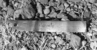 copper
bar found by Gilbert Minton near Blieblerville on a rise about 700 feet
above Spring Branch 0.8 miles southwest of FM 2502 (UTM coordinates 744600E,
3321800N) could well be an artifact lost by one of the travelers on the
Orcoquisac road, perhaps at the “La Zorilla” campsite.
The bar, 4 ¾” long, is engraved with the name “gerd david”
and an apparent date “1749”.
The French surname David was well established in Louisiana before
1800.
Members of the
David family are known to have been with the other French Britain families in Maryland and Louisiana.
copper
bar found by Gilbert Minton near Blieblerville on a rise about 700 feet
above Spring Branch 0.8 miles southwest of FM 2502 (UTM coordinates 744600E,
3321800N) could well be an artifact lost by one of the travelers on the
Orcoquisac road, perhaps at the “La Zorilla” campsite.
The bar, 4 ¾” long, is engraved with the name “gerd david”
and an apparent date “1749”.
The French surname David was well established in Louisiana before
1800.
Members of the
David family are known to have been with the other French Britain families in Maryland and Louisiana.
Also interesting is the legend told by early Oak Hill settlers of an "Indian trading post" on the west fork of Mill Creek about two miles above the juncture, and the presence of metal artifacts of pre-1900 vintage (a key, square nails, a copper brooch) as well as arrow points and other Indian artifacts at this location.
The establishment of Austin's Colony by Stephen Fuller Austin in 1822 and 1823 marked the beginning of a rapid influx of emigrant peoples to this previously unsettled land. The earliest families who colonized the area received land grants from the Mexican government of a league and a labor as an inducement for their settling the area. The center of Steven Austin's colony was the town of San Felipe de Austin, on the west bank of the Brazos River just downstream from the confluence of Mill Creek with the river. The early settlers choose lands primarily on and between the Brazos and Colorado Rivers. Settlement on the major tributaries followed. Three of these early land grants included the land between the lower forks of Mill Creek. A league each was granted to Benjamin Eaton (May 16, 1827) and George Grimes (March 16, 1831). On January 15,1830, the Mexican state of Coahuila y Tejas granted five leagues and five labors of land to Empressairo Stephen F. Austin in payment for having colonized five hundred families in Texas, as agreed in a contract with the Mexican government dated June 4, 1825. One league consisted of 4,428 acres of prairie and timber land, while one labor was 177 acres suitable for cultivation, normally adjacent to a river or flowing creek. Austin selected four leagues of this total in the forks of Palmito Creek, as it was then known in Spanish, referring to the “little palms” which then and now grow profusely in the flood plains. The waterway became known in English as Mill Creek after a grist mill was built on the Cummins Hacienda near present Millheim.
In April, 1831, German immigrant Friedrich Ernst and his family along with Charles Fordtran arrived in Texas, explored the land in Austin’s Colony and selected a West Mill Creek location because of its lush prairie, woods and ample water supply. Ernst acquired a league across the west fork of Mill Creek from the westernmost league in the S.F. Austin Four League grant and settled what later became the town of Industry. The Ernst homestead was quite isolated; during the early 1830s there were only two houses between Industry and San Felipe. Ernst was the first German to bring his family to Texas and came to be known as the “Father of German Immigration”. He sent a letter back to a friend in Germany in 1832 which was published in a newspaper, widely read and is credited with sparking what soon became a flood of German immigrants to Texas. Among those who were attracted by this letter and came to settle near Ernst included the families named Bartels, Zimmershied, Juergens, Amsler, Wolters, Kleberg, von Roeder, Frels and Biegel. The families of Karl and Marcus Amsler, Ludwig von Roeder, and Robert and Louis Kleberg founded the town of Cat Spring in 1834. The son of Robert Kleberg and Louisa von Roeder Kleberg, also named Robert and born at Cat Spring, married Alice King, daughter of steamboat captain Richard King who founded the legendary King ranch in south Texas. Kleberg took over management of the ranch after the death of Captain King.
In 1831 or 1832, James Gotier established a road called the Gotier (Gocher’s) Trace between San Felipe and Bastrop (then known as Mina). This road went through the nascent towns of Cat Spring and Industry and on toward La Grange, initially following the open country south of the timbered Mill Creek bottomland.
During the 1836 war in which Texas won independence from Mexico, one arm of the Mexican Army marched through Industry to San Felipe in pursuit of the retreating Texian Army. General Antonio Gaona arrived from Mexico in San Antonio on March 7, 1836, in time to participate in the Battle of the Alamo under the direction of Commander in Chief Antonio Lopez de Santa Anna. Following this Mexican victory, Santa Anna divided his army in pursuit of the retreating Texans under General Sam Houston. General Ganoa’s battalion left San Antonio on March 24, 1836, for Nacogdoches with a brigade composed of the Morelos battalion, Guanajuato auxiliaries, one eight-caliber cannon, two four-caliber cannons with their respective equipment and twenty presidial soldiers, reaching the Colorado River crossing on the San Antonio - Nacogdoches Camino Real near Bastrop in a few days. On March 31, Ganoa ordered his engineers to build rafts to cross the river, and on April 9 he recieved word from Santa Anna to redirect and hasten his march to rejoin the rest of the Mexican Army on the lower Brazos River after taking the town of San Felipe. Ganoa crossed the Colorado on April 13, and marched down the river toward San Felipe. Some of the carts were lost in the crossing, which meant heavier loads on the remaining carts, hence shorter marches.
On the night of April 15, 1836, Ganoa’s army camped near Mill Creek, having earlier that day torched the Ernst homestead at Industry. The precise route of Gaona’s march is not known. Local legend has it that the army went from Industry to their April 15 camp near Nelsonville, then on April 16 crossing the west fork of Mill Creek at Sycamore Crossing. An alternate and more logical route would have Gaona staying on the then-established Gotier Trace, marching from Industry to the New Ulm area, then through Cat Spring and on to San Felipe. This route would have avoided the two Mill Creek crossings that the route through Nelsonville would have entailed. Accounts of early residents living in the Cat Spring and New Bremen area that tell of Mexican army destruction of their homes in 1836 lend support that Gaona went from Industry to San Felipe on the Gotier Trace. Regardless of the logic of the Gotier Trace route, many of the early Nelsonville and Blieblerville area residents shared the legend of “Santa Anna’s” army passing through their area and perhaps burying some cannons or treasure at the Mill Creek crossings. Continuing from his Mill Creek campsite, on April 16 Ganoa encountered some dead Mexican soldiers hanging from trees and observed a large cloud of smoke from the retreating Texian’s deliberate burning of San Felipe. Ganoa arrived at San Felipe on April 17.
Stephen F. Austin died on December 27, 1836, followed about six weeks later by the death of his namesake nephew and heir. In his will dated April 19, 1833, Austin directed the disposition of his estate, including the division of a large amount of property including the Four League grant in Mill Creek between his sister Emily M. Austin (Mrs. James) Perry and his nephew and namesake Stephen F. Austin, son of his brother James E.B. and wife Eliza Martha Westall Austin. A legal battle lasting several years ensued between Austin's sister Emily and Eliza Westall (with her new husband Wm. G. Hill) over ownership of the lands in the estate of Stephen Austin. The estate dispute was finally settled on September 1, 1846, with the four leagues in Mill Creek being deeded to Guy M. Bryan, son of Austin's sister Emily by her first husband. The delay caused by these legal proceedings resulted in the major portion of the land in the forks of Mill Creek being unavailable for settlement during the time that much of the Cat Spring, New Ulm, Industry and New Bremen area was settled. Even before he had clear title to the land, however, Guy Bryan began to subdivide the four leagues and sell portions to settlers. By the mid-1850s, most of the original four leagues granted to Austin was sold to settlers coming to Texas from the southern United States who then established homesteads and cleared the land for farming employing the typical slave-plantation economy of their origins.
The first Czech settler in the area was Rev. Joseph Ernst Bergmann, who left Europe in 1849 and arrived at Cat Spring in early 1850. He, like Ernst, wrote ardently enthusiastic letters about the Cat Spring area “home” to the Kolacny family and other acquaintances in Europe. Several of the letters were reproduced in Moravske Noviny, a Czech-language newspaper which was circulated in Moravia and Bohemia. He liked the climate - apparently he must have encountered some unusually mild summers. He was impressed with the abundance of available land with timber and ater. He admired the local people, and especially appreciated the religious and political freedoms. By the end of 1848 many protestant Czechs felt that they had little chance of gaining relief from the authority of the Catholic church and the absolutism of Austria's repressive Hapsburg regime and were looking for places to emigrate. The encouraging letters about Texas from Bergman were welcome, and there was much enthusiasm about starting a new life in a new land. Meetings were held and plans were formulated for the transfer. Much of this planning was done under the leadership of Josef Lidumil Lesikar, an advocate of Czech migration. The first group of 74 Czechs left for Texas in late 1851 on the ship Maria, arriving at Galveston in early 1852 and finally reaching Cat Spring on April 5, 1852 after a devastating journey in which fewer than half of those who left Europe survived. About half of this group were members of the Silar (Schiller) family. Other Czechs on the Maria included those with surnames Coufal, Jezek, Lesikar, Mares (Maresh), Motl, Rosler, Rypl (Ripple), Silar (Shiller, Schiller), Szornovsky and Votava. Joseph Lidumil Lesikar and his family came with another smaller group of Czechs on the ship Suwa in 1853. Czech surnames in this second group include Busek, Cermak, Coufal, Janecek, Jares, Kroulik, Lesikar, Marek, Mares (Maresh), Pavlicek, Pechacek, Rypl, Silar, Slezak, Tauber and Zachar. Both of these first large groups of Czechs to come to Texas came from the Lanskroun and Litomysl regions of northeastern Bohemia – specifically villages named Horni Cermna, Nepomuky, Hermanice, Voderady and Dzbanov. Most initially settled among the Germans in the area around Industry, New Ulm, Frelsburg, Fayetville, Cat Spring and New Bremen. Members of these families and newer Czech immigrants after the Civil War, especially from the eastern Moravian region around Vsetin including villages named Hostalkova, Zadverice, Katerinice and Mikuluvka began moving to the Nelsonville area in the 1870’s. By 1880 the area within 10 miles around Nelsonville represented the greatest concentration of Czech-speaking peoples in Texas.
Early Settlers (prior to the Civil War)
21 OCT 1837: Bryant Daughtry bought approximately 3000 acres on the outside of the West Fork of Mill Creek from Von Roeder and Amsler, the original settlers of Cat Spring. Although their land was not between the forks of Mill Creek, the Daughtry's were part of the area community. Son James Daughtry married Isabel Thompson and lived on land near Nelsonville inherited from her mother Jane, one of the early settlers. The Daughtry's were in Texas when James was born on July 18, 1823.
4 JUL 1838: The first settler who bought land in the area of the lower forks of Mill Creek was John Pamplin Shelburne (also spelled Shelborn). Shelburnes first came to Virginia from England (Wales) in the early 1600s. Unconfirmed family history says young Thomas Shelburne came to Jamestown in 1607. John P. and his brother Samuel Shelburne were born in Virginia about 1791 and 1793, respectively. Their family moved to Tennessee in 1805, staying until 1830 when they moved 100 miles down the Natchez Trace to newly opened lands in the northwest corner of Alabama. In 1837 they pulled up again and moved to Texas. With John was his wife Nancy, her mother Jane Dunkin and 11 sons and daughters ages 2 to 22. Others in the wagon train were the Houchin, Barnett, Minton and Terry families. In October 1837 they were in East Texas and applied for 640 acres of new land near Rusk. Later they cancelled this application and moved on to Austin County. John P. Shelburne purchased 921 acres (Lot 10 west of the S.F. Austin Four League Grant) on July 4, 1838 between the West Fork and Blieblerville. Their homestead one mile southwest of Blieblerville was on a ridge separating Mill and Pecan Branches. In September 1842 John and his son-in-law Alfred Minton went to San Antonio to aid the Republic of Texas in repelling Mexican General Woll’s forces from the city. Later, on December 25, 1844, he purchased the next tract (1198 acres, Lot 11 West) up the West Fork toward present-day Welcome. The Shelborn's bought more land in the 1850's and 1860's, and operated a major plantation - based farming operation. John Shelborn owned 14 slaves in 1850, and 24 in 1860. Samuel Allen Shelburne, John P.’s eldest son, married Adeline Bell of Bellville and raised 14 children in the area. William Lewis Shelburne, John P.’s second son, married Mary Catherine Terry from the nearby Terry plantation.
9 SEP 1839: Alfred Minton bought 435 acres on the West Fork of Mill Creek immediately downstream from the original J. P. Shelborn tract. Minton was born in South Carolina in 1803, and lived in Alabama before coming to Texas, where he married Jane K. Shelburne, eldest daughter of John P. and Nancy. Nancy America Minton, daughter of Alfred and Jane, married William Brookfield Fordtran, son of Industry co-founder Charles Fordtran and Almeida Brookfield. Another daughter, Virginia Ann, married Dr. Robert Thompson of Nelsonville.
1841: Alexander Glenn (1812 – 1894) came from Georgia to Austin County where he married Sarah Pamplin Shelburne (1819 – 1899) in December of 1841 and settled in the Mill Creek forks area. The Glenn’s moved to Bellville in 1854, where they built one of the first homes in this new town. Glenn served as the Austin County surveyor from 1853 to 1860.
16 JUL 1844: John Bell purchased 125 acres of the Grimes League near the location of Nelsonville.
24 JAN 1845: Aaron M. Logan bought 125 acres on the West Fork just southeast of the location of Nelsonville. Logan was born January 1, 1800 in Tennessee and died September 13, 1881. His wife Elisabeth was born in 1825, in Alabama. In 1860, he owned three slaves.
9 NOV 1845: Mikajah Terry bought 545 acres on the West Fork. On February 7, 1847, Terry bought 574 acres adjacent to (downstream of) his original purchase; the northeast line of this tract borders the location of Nelsonville. On November 20, 1847, Terry bought additional land immediately south of the Nelsonville location. In 1850, Terry owned 8 slaves; ten in 1860. Terry and his wife Mary were born in South Carolina. A son William was born in Alabama in 1826, and two daughters Amanda and Martha were born in Mississippi in the middle 1830's. The Terry’s arrived in Texas with the Shelburne family in 1837.
3 MAY 1847: Jasper Daniel bought 100 acres on the East Fork below Nelsonville. On November 30, 1852, he bought 640 acres on the East Fork below the Jane Thompson tract. On April 8, 1853 he bought 507 acres on the West Fork below the juncture of Long Branch. On March 3, 1859, he bought 1040 acres on the East Fork at it's juncture with the West Fork. During the mid-1850's, Daniel bought several smaller, adjacent tracts between the two forks of Mill Creek, and by the late 1850's his plantation included approximately three thousand acres in the lower forks. He owned 9 slaves in 1860. Around 1860 he began subdividing and selling his land, continuing this into the 1870's.
8 JAN 1848: James W. Bethany bought two tracts in the S.F. Austin Four League grant from Guy Bryan. The main tract of 562 acres bordered the West Fork and extended to the Grimes grant just west of the future site of Nelsonville. The second Bethany tract was 156 acres between the West Fork and Long Branch at their juncture. James W. Bethany was born in 1834 in Alabama. The Bethany family came to Texas in 1846 or 1847. Thomas Bethany, the father of James W. Bethany, was living in the area in 1850, at age 72, presumably with his son. He was born in South Carolina. Thomas Bethany owned 41 slaves in 1850, and , together with James, thirty in 1860.
21 DEC 1848: Elias Elliot bought 252 acres of the George Grimes League. On April 1, 1851, he bought 165 acres between the locations of Nelsonville and Oak Hill. On August 25, 1852, he bought 694 acres of the Four League grant for $694 from Guy Bryan. This tract was located on the West Fork at the juncture of Long Branch. Elias Elliott was born in 1828 in North Carolina and came to Texas sometime before the birth of a son in 1842. He owned 2 slaves in 1860. He and his wife Frances were born in North Carolina. Living with them in 1850, were Samuel Eliot (a schoolteacher, apparently not related) and son William, plus Joshua and David Ward.
4 DEC 1849: John Ward bought 418 acres from Guy Bryan on the East Fork at the lower edge of the Grimes League. He was born in North Carolina in 1820 and was in Texas in 1848 when his son Jasper was born. His wife Martha was from Tennessee. On December, 1850, Solomon Ward bought 150 acres north of Welcome. One of the Wards was an early surveyor in the area.
8 MAR 1850: William Norcross purchased 180 acres of the Four League grant from Guy Bryan for $180. Norcross was born in 1810 in New Jersey, coming to Texas sometime before the birth of a son George in 1846. He owned one slave in 1850. He owned land in the Grimes League in 1844, when John Bell purchased an adjacent 125 acres.
21 DEC 1850: John Manley bought 525 acres immediately southeast of Nelsonville. At the time of this purchase he was from Walker County, Texas. In 1860, Manley owned 7 slaves.
4 OCT 1851: Jane Thompson bought 646 acres on the East Fork between the locations of Oak Hill and Nelsonville. In 1865, the estate of Jane Thompson was divided among her children R. W. Thompson, Margaret Willis, Isabel Daughtry, W. A. Thompson, and George Foster (for his minor children by a Thompson, Charles and Fannie Foster).
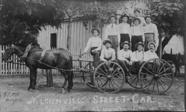
24 SEP 1852: Ransom G. Burns bought 100 acres in the Kuykendall survey just south of the west fork of Mill Creek. He later bought 409 acres in Lot 4 in 1865, and a town lot in Nelsonville in 1867. Burns was born in either Virginia or North Carolina around 1800. He is listed as 48 years old in the 1850 Austin County census, and as 76 years old on his tombstone in 1874. He married Achsah Lee Bunn or Burn in 1834. She was born in 1813 in Goldsboro, North Carolina, daughter of Tobias Burn or Bunn and Anny Lee. Anny’s grandfather’s father was John Lee, Esquire, a large plantation owner southeast of Raleigh, North Carolina, in the early 1740’s. Ransom and Achsah arrived in Texas November 18, 1841, first settling in the Brushy Creek community in northwest Walker County, where he applied for a land grant and was allowed 640 acres in Robertson or Fannin Counties. No record exists of his occupying this land. The Burns family moved to Austin County sometime after 1843. The Burns are listed in the 1850 Austin County census with 10 or 11 children. Thomas was born in North Carolina, Sarah, Narcissa and Frances in Alabama, Felix in Mississippi, and John, Nancy, Joanah (Joan D’Arch) and Tobias (Napoleon) in Texas. Mary Burns, age 24 and born in North Carolina was living with the family in 1850 with her 3 year old son John. Ransom Burns was a farmer, merchant and cotton broker. He may have had a store in Nelsonville, and son Napoleon is listed as a merchant in the 1880 census. Ransom died on March 31, 1874, and was buried in the Burns cemetery near his Oak Hill homestead. After his death, Achsah moved to Milam County to be with or near her daughters. Sons Thomas, Felix and John remained in the area. Felix and John joined the Confederate army (Company A, Elmore’s 20th Regiment, in Galveston for duration of war). Felix married Helen Trott and lived on a farm on the Kenney-Travis road at Buffalo Creek; their youngest daughter Ollie taught at the Nelsonville school in 1911. Thomas and John moved to Bellville where John and wife Rosa ran a hotel.
28 JAN 1854: Thomas and Malinda Willingham Flake bought 203 acres and 25 acres on the East Fork near modern Oak Hill. Thomas was born in 1800 in Kershaw District, South Carolina. In 1840 and 1850 he was in Neshoba County, Mississippi, where he operated a plantation with five slaves. His grandfather Samuel Flake of Anson County, North Carolina, was one of the signers of the Mecklenburg Declaration of Independence. His father Thomas Flake lived in Lime County, Alabama and Kersaw District, South Carolina. The Flakes were listed in the 1860 census in “Forkston” as Thomas (age 60), Malinda (57, born in Georgia), Steuben D. (22, born in Alabama), Thomas M. (21, Mississippi), Elizabeth (19, Mississippi) and Lafayette (15, Mississippi). His occupation was “farmer”, with real estate valued at $1550 and personal property of $9,800. On March 16, 1863, The elder Flakes deeded the following slaves to their sons Steuben and Lafayette: Nelson (32), Ferrel (24), Richard (21), Henry (21), Ann (5) and Jerry (3). Steuben Flake was a partner with Issac Lewis and J. W. Bethany in the Nelsonville mercantile store. He married Mary Bethany, daughter of James W. Bethany; she died in 1865. He sold his property in Nelsonville on December 21, 1871, to Mathias Christopher and John Baletka, moving to Hayes County, Texas, where he died in 1879.
29 OCT 1856: Eldridge C. Williamson bought 87 acres from Elias Elliot near the location of Oak Hill. Williamson was born 14 Nov 1833 in Georgia, son of Eldredge Williamson and Nancy Clark Hart. He married Mary E. Johnson on 31 Oct 1854 in Washington County, Georgia. She was born about 1832 in South Carolina, daughter of Seaborn Johnson and Barbara McGraw White. They moved to Texas in 1854-55. Williamson’s wife Mary died 8 June 1904 in Wesley, Washington County, Texas. E.C. died 16 July 1881 in Nelsonville. Their children were (1) Jasper N. Williamson, born 7 March 1855 in Nelsonville; married Annie S. Jones in Bellville, 3 January 1883. Later spouses were Carrie B. Power and Caroline (Lina) Wittenburg. Died 23 October 1924 in Thrifty, Brown County, Texas. (2) Nancy Catherine Williamson was born 15 December 1856 in Nelsonville; married Elbert T Creekmore in Bellville on 5 December 1877 and died in Bellville 17 July 1942. (3) Mary C. “Molly” Williamson was born January 1858 in Nelsonville; married C. Franklin Campbell in Austin County on 11 September 1879. (4) Georgiana Williamson was born 1860 in Nelsonville; married Tom A. Fincher in Texas on 10 October 1890; died in Burton, Washington County, on 4 April 1927. (5) Elizabeth F. Williamson was born October 1862 in Nelsonville; she married Louis F. Lee in Austin County on 8 November 1883. (6) Sarah Paulina Williamson was born August 1865 in Nelsonville; she married Marion Randolph White, Jr. in Austin County on 30 September 1887 and died in Texas 21 October 1940. (7) Eldridge C. Williamson, Jr. was born 24 January 1869 in Nelsonville and died 18 April 1889 in Jackson County, Texas.
The slave census of 1850 shows an E. C. Williamson owning one slave. Perhaps this slaveowner is Eldredge, father of E.C., who may have moved to Texas ahead of his family and was living in the area in 1850. His son Eldridge was 17 years old and still in Georgia in 1850; he married in Georgia in 1854 and did not move to Texas until around 1855.
Forward to Settlement p. 13 - Back to Settlement
