|
Texas Historic Marker |
Location
& Description |
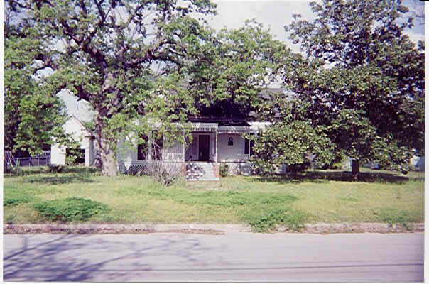
Adams-White Place
|
30
52 26 N / -96 35 26 W
[1105 Magnolia Street,
Hearne]
Map
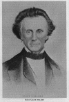
"Built
1896 by Horatio "Rashe" Adams, noted
citizen and public relations man in Washington, D.C. The contractor was
A. A. White. After 1911, the house was called the "Dr. John L. Black
Place" for its owner. It was later sold to Mrs. Willie L. Moreland. In
1924, the house was purchased by Miss Lil White, present owner.
Victorian in style, structure had a separate kitchen [now the garage]
once supplied with water from a backyard artesian well." [#10896/1968] |
|
Jacques Adoue
Building
|
30
58 45 N / -96 40 28 W
[506
Main Street [Hwy. 6], Calvert]
Map
"Relic
of colorful career of Jacques Adoue [1851 -
1906], youngest of three French brothers who came to Texas [1860s] to
become Calvert, Dallas, and Galveston business leaders. Jacques Adoue
owned numerous enterprises. This store, built in 1884 for Collat,
Adoue, and Risser Dry Goods, set an ambitious style for the town. It
was said by friends that Adoue's death, years later from injuries
sustained in Calvert Compress fire, marked passing of an era." [#10897/1973] |
|
Allen Hardware
Store
|
30
52 49 N / -96 35 42 W
[111 Third Street [3rd
& Magnolia Streets], Hearne]
Map
"Built
1872 on land purchased from
International Railroad Company by Drew and Holt of Hearne. After
ownerships by James Ferguson, W. T. Watt, R. A. Allen, and H. K. Davis,
Allen bought store in 1891; was joined by son Robert. Their heirs still
own and operate the store. Goods carried in the past included seeds,
saddles, wagons, building hardware, implements, and coffins."
[#10898/1968]
|
|
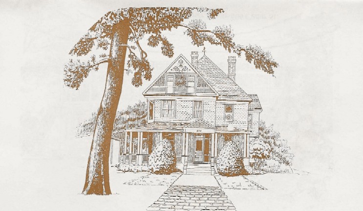
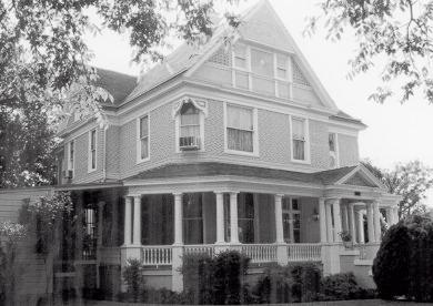
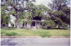
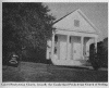
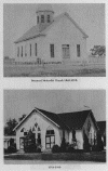
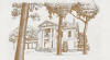
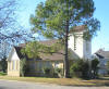
Robert Cyrus
Allen Home |
30 52 43 N / -96 35 45 W
[402 Cedar Street, Hearne]
Map
(see photos above)
"Hearnewood.
Robert Cyrus Allen [1871 - 1933] had
this Victorian residence built in 1900 as a wedding present for his
wife Florence [Blair]. A prominent area merchant, banker, and civic
leader, Allen also served as mayor of the city and was instrumental in
the organization of the Hearne & Brazos Valley Railroad. This
house, constructed on the site of his family home, was designed by the
noted Waco architect W. W. Larmour. The exterior features decorative
shingling and classical revival detailing. Interior furnishings include
intricate woodwork and seven fireplaces." [#10899/1981] |
|
|
Bald Prairie
Cemetery |
31
13 16 N / -96 25 53 W
[junction
FM 979 & FM 2096]
Map
"A
leading citizen, Elijah Rains [1813 -
1889], who came to Texas from Tennessee in 1848 gave this burial ground
to the public. Duck Creek people soon joined the Prairie people in its
use. The earliest known burial was Walter Pirtle, date uncertain. The
grave of Samuel E. Lightsey [1827 - 1872] has the oldest marker.
Veterans of the Civil War and later conflicts are buried here. The
Cemetery Association was formed in 1928. In 1957, Gilbert Sterling Ross
added a donation of one acre to the original five-acre plot. Annual
Memorial Day services honor some 700 marked graves." [#10900/1976] [see
Bald
Prairie Cemetery] |
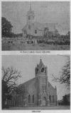
Bald Prairie
Church of
Christ |
31
13 16 N / -96 25 57 W
[junction FM 979
& FM 2096]
Map
"Organized
in 1847, this fellowship
worshipped with members of the Baptist Church until the groups
separated in 1849. A log structure served the 15 charter members of
this congregation as a church and school. Elijah Rains [1813 - 1889]
donated land for the church and community cemetery. The present
building, erected during the 1880s, doubled as a school for over 20
years. It also served as a funeral chapel and social and cultural
center for the community. The classrooms were added in 1940.
Descendants of early members still worship here." [#10901/1976] |
|
Barton Home |
30
59 02 N / -96 40 06 W
[409 Maple Street
[Mitchell
& Maple Streets], Calvert]
Map
"After
new home north of Calvert was
destroyed by fire, Winnie Walker Burnitt Barton, widow of plantation
owner Francis Davis Barton, built this structure in 1909. She intended
the brick home with slate roof to withstand as many natural disasters
as possible. Classical Revival in style, the house boasts colonnaded
porches and balconies on three sides, 18-inch exterior walls, and
12-foot ceilings. The three Barton daughters hosted large house parties
here." [#10902/1978] |
|
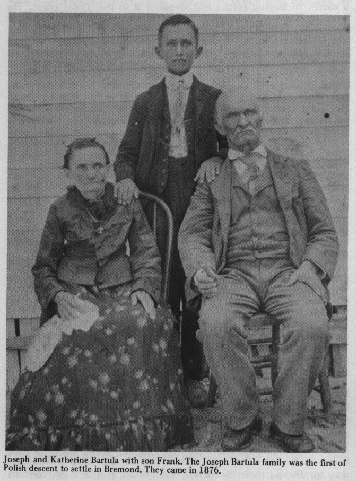
Joseph &
Catherine
Bartula

|
31
10 20.7 N / -96 40 16.4 W
[Saint
Mary's Catholic Cemetery, FM
2854 & FM 2413, Bremond]
Map
"Born
in Poland, Joseph [1840-1919] and
Catherine [1841-1907] Bartula overcame many hardships after migrating
to Texas in 1873. They became the first Polish settlers in Robertson
County in 1875. Assisted by J. C. and Mary Roberts, on whose farm he
worked, Bartula wrote letters urging other Polish immigrants to join
him. Soon 50 families arrived from Poland and 60 moved here from the
Marlin area. By 1885, the town of Bremond had the largest Polish
settlement in Texas, 345 families. Bartula later bought his own farm
and became a leader in community and church affairs. The Bartulas had
ten children." [#10904/1975] [see Bartula
Journal & Polish Collection]
|
|
Brazos
Manufacturing
Company, C.S.A.
|
30
52 55.9 N / -96 34 44.2 W
[east city limits on FM
391 in
Hearne]
Map
This
marker may not be correctly placed.
The actual site of the Brazos Manufacturing Company is located on
private land previously owned by the Easterwood family on Pin Oak
Creek, to the right about a mile off the road [near 30 54 01 N / -96 32
06 W] when going from Black Jack toward Wheelock. Ruins remain; a small
Easterwood Cemetery is rumored to exist at the site.
"Established in 1863 on a
Brazos River
tributary. Intended to make flour and cloth of cotton and wool.
Chartered by 9th Texas Legislature in all-out effort to supply the
goods necessary to Confederate victory in the Civil War. Up to now
Texas had not had factories because she could more economically trade
agricultural products for manufactured goods. Wartime imports, however,
were limited to small shipments run in through Federal coastal
blockades. To finance its purchases of machinery, materials and labor,
Brazos Manufacturing Company received cotton from Texas planters,
especially in this area. Subscription of a bale of cotton gave a
planter the right to export one bale for his own benefit. Since neither
factory nor farm had any other way to pay running expenses than by
cotton sales, much cotton was donated to the corporation. This
corporation met the fate of many chartered by Texas during the Civil
War: paper mills, bridge and ferry companies, iron works, railroads,
foundries, cotton cards plants and others. Although Brazos
Manufacturing Company did help to clothe army and civilians, its
production was small and was achieved too late in the war."
[#10903/1965] |
|
Bremond
|
31 09 57 N / -96 40 32 W
[117 S. Main Street, Bremond]
Map
"Part of the 1841
Mary Peterson grant, the land on
this site was sold to William Baker and a group of investors in 1869.
The investors immediately granted right-of-way to the Houston and Texas
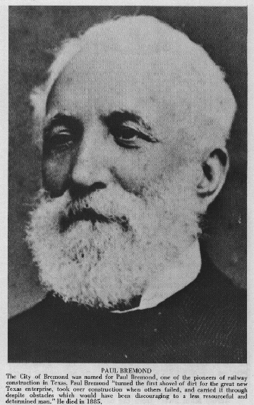
Central Railway. The first train pulled into Bremond, named for
railroad executive Paul Bremond, in 1870. It was met by a crowd of more
than 1,000. The town was incorporated and a post office opened that
year with Sam Morehead as postmaster. By 1871 Bremond had several
merchants, churches, three doctors, a law firm, a school and a
newspaper called The Central Texan. Joseph Bartula and his family were
among the first of many Polish immigrants to arrive in the 1870s. The
town continued to grow throughout the 19th and 20th centuries. In 1999,
Bremond had an estimated population of 1,300." [#11694/2000] |
|
|
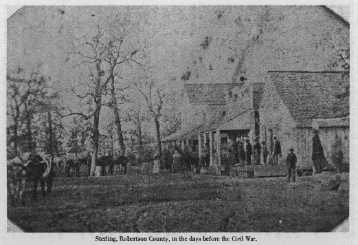
Calvert
|
30 58 42 N / -96 40 26 W
[Main [Hwy. 6] & Burnet Streets, Calvert]
Map
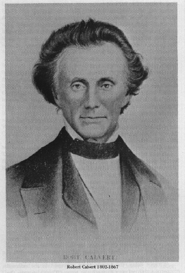
"Town Of Calvert.
Swarming ox-carts and cotton
wagons, busy stores and saloons, casino tables stacked with gold: this
was early Calvert, a major cotton export and trade center. Community
began as "Sterling," in Sterling C. Robertson colony of the 1820s. It
was center of mustering and military supply activity in Civil War,
1861-1865. When Houston & Texas Central Railroad route was
established here, 1868, town was moved 2 mi. to the right of way and
renamed for Judge Robert Calvert, pioneer Texan, local landowner,
benefactor, and civic leader-- a descendant of Lord Baltimore of
Maryland."
[#10905/1968] |
|
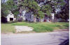
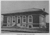
|
Calvert
Courthouse
[also known as
Hammond House] |
30
58 50 N / -96 40 12 W
[bounded by Burnet,
China, Elm,
& Hanna Streets, Calvert]
Map
(see photos above)
"Former
Calvert Courthouse. Most impressive
public building in early Robertson County. After becoming county seat
in 1870, Calvert lost many leaders in 1873 yellow fever epidemic. As
planned, this courthouse was begun in 1875; but before its completion,
Franklin was named county seat in 1879. Robert A. Brown, a merchant,
investor, and planter, purchased this building in 1885. With help of
his wife, Lucy Herndon Brown, he made it into a residence. In 1909, his
heirs sold it to Mrs. Fannie L. Hammond, in whose family it remained
until 1966, when it became a museum." [#10906/1968] |
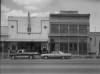
|
Calvert Foundry
&
Manufacturing Company
|
30
58 45 N / -96 40 29 W
[502
Main Street [Hwy. 6], Calvert]
Map
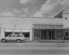
"Old
Calvert Foundry & Manufacturing Company.
Founded in 1870 as one of Calvert's first industries, the building is
of country-made brick; iron facade came from St. Louis. Iron ore from
local deposits and from Cherokee County [100 miles Northeast] was
hauled here by horse-drawn wagons to be made into form tools and other
sturdy articles. Prominent Texans have owned this foundry. J. Adoue,
member of a French family noted in state business, was an incorporator." [#10907/1969] |
|
Camp Creek
Cemetery |
31
02 13 N / -96 21 18 W
[US 79 east, FM 1940
south, CR 324]
Map
"In
1859,
Ashbel Smith donated the ten acres for the cemetery. Smith, a medical
doctor
born in Hartford, Connecticut, came to Texas in 1837 and was an
outstanding
state leader. A log cabin, built on the northwest corner of the tract,
served as
a community school and church. The oldest grave marker is that of Lucy
M. Turner [1824 - 1864]. While crossing Camp Creek in 1869, Ann
Marjorie McQuistion [Mrs.
Edward] McMillan was killed when a panther attacked her buggy horse.
She was
buried here along with many children who died of malaria and typhoid."
[#10909/1976] [see Camp
Creek Cemetery] |

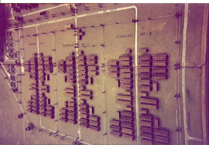
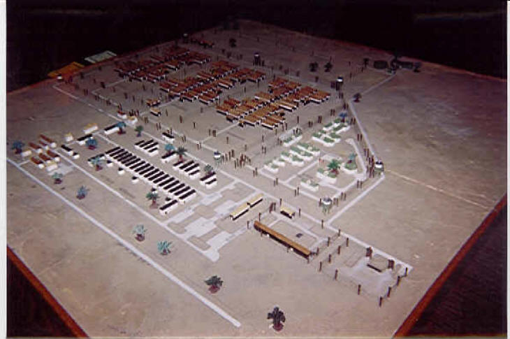
Camp Hearne

|
30
53 15 N / - 96 37 03 W
[Hearne -- Not
Yet Placed]
Map
Texas
Historic Marker Pending
"During the Second World War, allied
troops captured large
numbers of Axis soldiers and transported them to prisoner of war camps
established throughout the United States. More than 70 camps in Texas
housed some 50,000 prisoners. In March 1942, Hearne Chamber of Commerce
President Roy Henry contacted Congressman Luther Johnson to request
that a camp be located here. Within a month, U.S. Army staff had
inspected the area and selected 720 acres as a prison site.
Construction of the camp began in September 1942 and was completed in
six months. It was laid out in three sections, each of which included a
mess hall, lavatory, company office and eight barracks. The first of
almost 5,000 prisoners of war (POWs) arrived in June 1943. Most of the
POWs housed here were non-commissioned officers (NCOs) of the famed
German
Afrika Korps captured in
Tunisia. Because NCOs were not required
to work in prison camps according to the Geneva Convention, they spent
most of their time in recreational and educational activities while the
bulk of the work in the camp fell to enlisted men who comprised about
twenty percent of the prison population. In 1944, Camp Hearne became
the central mail distribution point for all German POWs in the U.S.,
but poor supervision allowed a small group of Nazi sympathizers to
infiltrate the system and intimidate and terrorize both prisoners and
their families back in Germany until the scheme was discovered and the
operation shut down in July 1945. A few hundred Japanese prisoners were
brought here in the summer of 1945 shortly before the end of the War.
All POWs were gone and the camp closed by January 1946."
[see
Camp Hearne Collection] |
|
|
Casimir Drugstore |
30
58 44 N / -96 40 27
[512 Main Street [Hwy.
6], Calvert]
Map
"Sometime
after 1869, Jean Pierre Casimir
[died 1929], native of Toulouse, France, built this structure. His
family operated drugstore here until 1949. A patio in the rear
connected drugstore to the Palace Opera House, also owned and operated
by the Casimir family." [#10910/1973] |
|
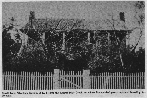
Cavitt House
|
30
53 51 N / -96 23 41 W
[1/2
mile west of Wheelock on FM 391]
Map
"Old
Cavitt House. Republic of Texas
homestead established when log cabin was built 1836. Main house of hand
finished lumber, begun in 1842, completed in present form 1854. During
1840s and 1850s, was stage stop between Nacogdoches and San Antonio de
Bexar. Cavitts were political followers of Sam Houston, friend and
frequent guest here, who gave a desk to Volney Cavitt." [#10911/1964]
|
|
Chinese Farmers |
30
58 41 N / -96 40 27 W
[617 Main Street [Hwy. 6], Calvert]
Map
"Home
Area Of Chinese Farmers. Imported from Asia
about 1874 to help in cotton fields, these exotic workers were queues
and attracted much notice. At least 24 families were brought here; many
became permanent residents, respected for their good work. Over 25
ethnic groups settled in Texas-- many having preceded the Chinese.
Other than American Indians, first permanent Texas settlers were cattle
raisers from the Canary Islands. Other migrant groups included Cuban
cigar makers and European lace makers. Given new opportunities, their
descendants now are in industry, business, professions." [#10912/1968] |
|
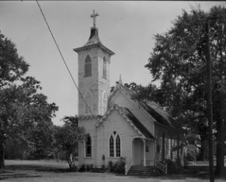
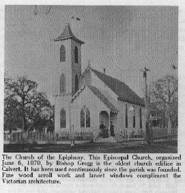
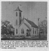
Church Of The
Epiphany
|
30 58 47 N / -96 40 10 W
[700 Gregg Street
[corner Gregg & Elm], Calvert]
Map
"Organized June
6, 1870, by Bishop Gregg. Oldest
church edifice erected in Calvert. Has been used continuously since
parish was founded. Fine wood scrollwork and lancet windows compliment
the Victorian architecture." [#10913/1967] |
|
|
|
|
Citizens Bank
&
Trust Company Building |
30
58 41 N / -96 40 25 W
[620 Main
Street [Hwy. 6], Calvert]
Map
"Built
1868 by James S. Hanna, for a general store.
Owned 1870 - 1871 by a Battle of San Jacinto veteran, the Revered
Robert Crawford. Bought 1872 by J. S. McLendon, whose store and private
bank were housed in the structure. In 1887 this was site of founding,
first National Bank of Calvert; later renamed Union State Bank; finally
Citizens Bank & Trust. Exterior remains 1887 style." [#10914/1968] |
|
Cobb's Market |
30
58 43 N / -96 40 29 W
[515 Main Street [Hwy. 6], Calvert]
Map
"Original
meat market here in 1868 was remodeled
into present Victorian building of handmade brick in 1878, by Mrs. Ella
Oscar. Original fixtures still used include wood burning stove of cast
iron, marble top counters, meat saw rack." [#10915/1967] |
|
Dunn Cemetery |
30
51 58 N / -96 25 40 W
[Wheelock]
Map
"Started
in pioneer era on land of James and
Isabella Caufield Dunn, who with 8 other families came from Ireland to
America in 1821, living first in Charleston, S. C., then in Boligee,
Ala. In Dec. 1833 they began trek to colony of Sterling C. Robertson by
ox-wagons and carryalls. With the Dunns were families of Henry
Caufield, Letitia Ellis and her daughter Elizabeth Watson, Henry and
William Fullerton, Hugh and William Henry, the widow McMillan, and the
Youngs. Burial of infant of James and Isabella Dunn [1836] opened this
cemetery, used ever since by heirs of the pioneers." [#10916/1972] [see
Dunn
Cemetery]
|
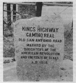
El Camino Real
[also
known as
Old San
Antonio Road
& Old
Spanish Trail]

|
30
45 20.7 N / -96 27 03.9 W
[1 mile east of Hwy 6 at
Benchley on Old San Antonio Road; beside Staggers Point marker]
Map
"A
trail of adventure, opportunity,
hardships, and freedom, over which history stalked into Texas. To the
Spanish, El Camino Real was a road travelled for the King - to
colonize, christianize, seek adventure, and look for riches. This road
became the most famous. Its many parts were made, discovered, or known
hundreds of years before 1691, when Domingo Teran De Los Rios, first
Texas governor, joined and marked the different trails for the King. It
was the route from Monclavia [crossing the Rio Grande near Eagle Pass]
to the missions of East Texas. Probably its trailblazers were buffalo
and Indians, or Aztecs on trading expeditions. It was also possibly
traveled, described, and changed in part by French explorer LaSalle; by
Alonso de Leon & Father Damien Massanet planting missions in
East
Texas; and by the French nobleman St. Denis seeking trade along the Rio
Grande. As the years wore on, it was traveled in 1820 by Moses Austin,
as well as by thousands of settlers who followed him. San Augustine
Nacogdoches and San Antonio were its principal cities and inns sprang
up along the way. Soldiers and supply trains used it during the Texas
Revolution, Mexican War, & Civil War. It is still followed in
part
by this highway." [#10908/1972]
|
|
Elmo Baptist
Church |
30
59 54 N / -96 37 29 W
[near
intersection of Hwy. 1644 & Elmo Road between Calvert &
Franklin]
Map
"Site
Of Elmo Baptist Church. W. Cox started
a Sunday School at the Elmo schoolhouse [125 ft. SE] in 1899. Later
that year, with the help of the Rev. R. M. Crawford, a Baptist church
was organized. A separate sanctuary was built in 1907 and Baptist
ministerial students served the congregation as weekend pastors. The
school consolidated with the Calvert District [3 mi. W] in the 1940s
and the church building was moved adjacent to the schoolhouse. Despite
the declining population of the area, members continued to worship here
until 1969 when they merged with the First Baptist Church of Calvert."
[Note: the old church has been converted into a house.]
[#10920/1980] |
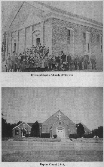
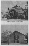
First Baptist
Church
Of Bremond

|
31
09 44 N / -96 40 52 W
[705 S. Austin Street,
Bremond]
Map
"Local
lore dates the origin of this church
to 1865; however, the earliest written source indicates that a Bremond
Baptist Church was in existence by 1869. The first members met in
vacant store buildings under the leadership of the Reverend Mr. Harris.
In 1869 or 1870 the church joined the Waco Baptist Association. A red
brick structure was erected on this site in 1871. An 1876 record lists
the church as the first Missionary Baptist Church of Christ of Bremond.
With a membership of 148 in 1879, the church began to prosper under the
pastorate of the Reverend C. C. Lee. The congregation joined the Little
Brazos Association in 1880 and drew up a church covenant four years
later. In 1899, the church joined the Robertson County Baptist
Association. By 1933 the church was well established and deeply
invested in community and missionary work. Plans for new facilities
were underway by June 2, 1945, when a check to apply to a new building
was received. That night, a storm destroyed the roof of the original
structure. Through insurance, loans from members, and gifts,
construction on a modern edifice was completed in 1946. Church members
gave their own monies to defray the church's debt. First Baptist church
members have long been active in worship and service. Through
missionary projects in Mexico and Brazil, local community work,
interdenominational services, and educational support, the congregation
continues in the traditions of its founders." [#11757/1998]
|
|
First Baptist
Church |
30
58 52 N / -96 40 15 W
[corner Elm &
Burnett,
Calvert]
Map
"As
early as 1835, Baptists were worshipping
in this area. In 1868, when Calvert was founded, Houston &
Texas
Central Railroad donated lots for a church. Until a brick edifice was
built in 1873 on that land [at Hanna and Pine], services were held in a
private residence. This church was host [1875] to Baptist State
Convention; [1875, 1878] the State Sunday School Convention; [1912]
Hood's Texas Brigade Reunion. Sent [1907] Alyne Guynes Muirhead and
[1915] Sammie Guynes Johnson as missionaries to Brazil. Since 1947,
sponsors Mexican mission. Elmo Baptist Church merged with Calvert,
1969." [#10921/1972] |
|
First Baptist
Church
|
30
52 40 N / -96 35 36 W
[105 W. Davis
Street [corner Davis & Magnolia],
Hearne]
Map
"Organized April
18, 1869, as 'Hearne Station
Baptist Church', with eleven charter members. After great revivals
under the Reverend 'Major' Penn, and a gift of a site by incorporation
of Southern Pacific Railroad, a Sanctuary was built in 1877. Pastor H.
R. Carroll and congregation laid the cornerstone September 2, 1907, for
a new auditorium adopting the name 'First Baptist Church'. On January
23, 1966, present church was dedicated under leadership of the Reverend
James E. Scirratt. This congregation organized and in 1969 erected a
building for a Mexican Baptist Mission." [#10922/1969] |
|
|
|
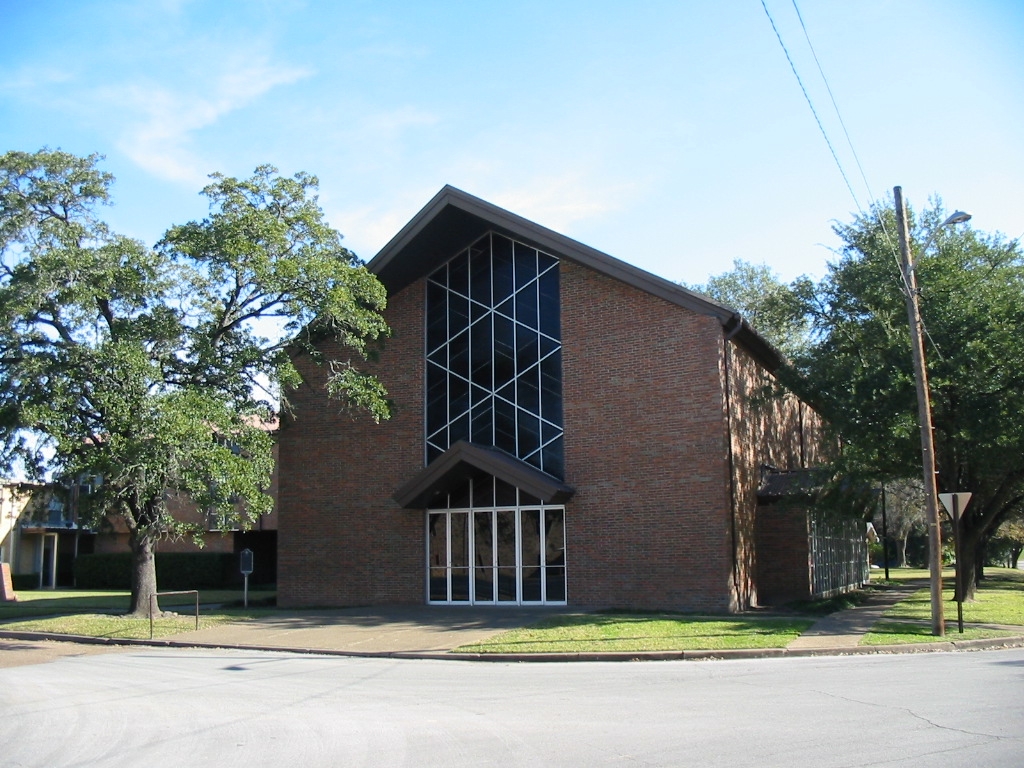
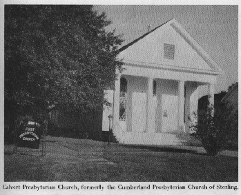
First
Presbyterian
Church
|
30 58 55 N / -96 40 22 W
[401 N. Barton Street [corner Beech &
Barton], Calvert]
Map
"Built at
Sterling before Civil War on land of Judge
Robert Calvert, Texas legislator and descendant of Lord Baltimore
[Maryland colonizer]. Stained glass in windows was imported. Other
materials and labor were from Calvert's plantation. Calvert's heirs
gave building to the church - then Cumberland Presbyterian. It was
moved to Calvert in 1868, remodeled 1877, placed at this site 1913."
[#10923/1967] |
|
|
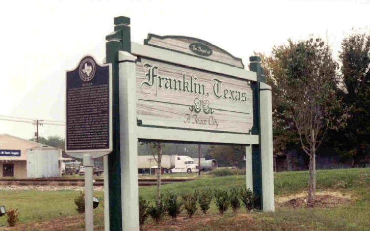
Franklin
|
31
01 30 N / -96 29 09 W
[Hwy. 79 & FM 46,
park near
railroad tracks]
Map
"This
community was established in 1872 and
named Morgan for a railroad official. Located on the right-of-way of
the International Railway Company, the town contained a depot and three
stores in its first year. By 1879, the town had 200 residents and
voters transferred the county seat from Calvert to Morgan. The
community applied for a post office in 1880. Another Texas post office
was named Morgan, so the town name was changed to Franklin after the
name of the original county seat. A stone courthouse, designed by R. E.
Ruffini, was completed in 1882. The town's first newspaper, the
Franklin Weekly, was published by J. A. Keigewin. By 1885, Franklin had
three hotels, three churches, and two gristmills. Mineral springs
attracted people to the area for many years. A cemetery was formally
established in 1880 at a site where several graves were already in
existence. The community's first school building, a frame structure,
burned in 1894 and another was erected. The First National Bank of
Franklin was charted in 1905; the First State Bank was established in
1913. A Carnegie Library was built and equipped with an auditorium. By
the 1970s, Franklin, an incorporated community, had a mayor-council
form of city government." [#10924/1997] |
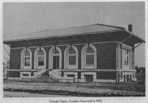
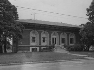
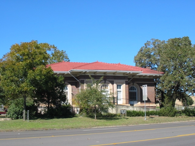
Franklin
Carnegie
Library
|
31 01 37 N / -96 29 02 W
[corner Decker & Owensville Streets, near
Hwy. 79]
Map
"The City of
Franklin housed a library of 1,000
volumes in its city hall before 1913. In February that year, Franklin
Mayor R. M. Cole [1848 - 1931] applied to the Carnegie Corporation of
New York for funds to build a new library. The Carnegie Corporation
approved plans and granted $17,500 to the project. This building with
classical details and a pressed metal roof resembling tiles was
designed by an architect named Patterson and completed in 1914, though
it served as a library only through 1918. School classes and public
activities were held here through 1984." [#10925/1986] |
|
|
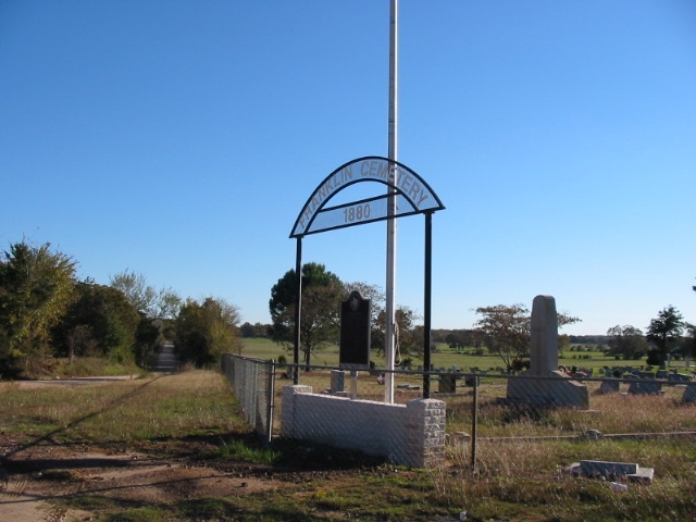
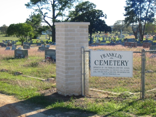
Franklin Cemetery
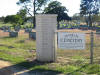

|
31
00 57 N / -96 28 54 W
[junction FM 462
& CR 324,
1.5 miles south of Franklin]
Map
"The
community of Franklin was originally
established in 1872, and named Morgan for an official of the
International Railway Company. By 1879, the town had 200 residents.
When the community applied for its post office, another Texas post
office was named Morgan, so residents changed the name to Franklin
after the original county seat. a five-acre plot of land for a
graveyard was deeded to Robertson County in 1880 as part of an
incentive to persuade officials to locate the county courthouse in
Franklin. However, six tombstones on this site predate its official
designation as a graveyard. The first recorded burial is that of
Elizabeth Calvert in 1869. Among the more than 1,300 graves are members
of fraternal organizations, and veterans of the Civil War, Spanish
American War, World War I, World War II, Korea, and Vietnam. C. N.
Brigance, veteran of the War of 1812, also is buried here. Interments
include those of former city and county officials, state legislators E.
A. Decherd and T. L. Goodman, and four local musicians who achieved
national fame. The Franklin Cemetery continues to serve the citizens of
Franklin and Robertson County as it has for more than 100 years."
[#10926/1997] [see Franklin
Cemetery ] |
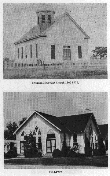
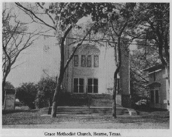
Grace United
Methodist
Church |
31 09 55 N / -96 40 47 W
[317 S. Austin
Street, Bremond]
Map
"This
congregation was founded in 1868 as the
Bremond Methodist Episcopal Church, South, with the Reverend John R.
White serving as pastor. The earliest worship services were held in
private homes or in the community's Union church. Two early Methodist
church buildings were rebuilt after damage from windstorms, and a new
sanctuary replaced the one lost in a 1949 fire. The congregation
changed its name to "Grace Methodist Church" in the 1950s."
[#10927/1985] |
|
|
Dr. Benjamin
Franklin
Hammond |
30
58 53 N / -96 40 07 W
[Calvert
Cemetery]
Map
"Prominent
physician, planter,
industrialist, political leader. As a ;man of wealth, came [1852] to
Texas from Huntsville, Alabama, with family, slaves, cattle, horses,
and ox-train of property. Bought extensive lands here. After Civil War,
gave about 160 acres to each household of his ex-slaves, but
carpetbaggers nevertheless put him in Calvert's tree prison. Married
four times; had a son William Eli Hammond; two grandchildren."
[#10928/1973] |
|
Hammond |
31
05 43.7 N / -96 42 53.4 W
[6 miles north of Calvert on Hwy. 6]
Map
"Site
Of Extinct Town Of Hammond. Dr. Benjamin
Franklin Hammond moved here from Alabama in 1853 and built a plantation
home about a mile to the west. Neighbors included James Love and Robert
S. McCall. Hammond depot and post office were opened at this point on
the Houston & Texas Central Railroad after the doctor granted
right-of-way through his land in 1869. Near the depot, used by planters
for their shipping, were a few stores. As the railroad declined, the
town had vanished by 1950. Area residents are mostly the descendants of
persons given land at emancipation [1865] by Dr. Hammond and other
planters." [#10917/1976] |
|
Harvey Massacre |
31
02 48.4 N / -96 42 37.8 W
[5 miles north of Calvert on Hwy. 6]
Map
"At
this site one Sunday night in November 1836,
the family of John Harvey was attacked by an Indian raiding party.
Harvey, his wife, and son were all killed, Mrs. Harvey's blood staining
the open pages of the family bible. Their daughter Ann Elizabeth, aged
5, and a servant girl were taken captive, later to be sold as slaves.
The price of Ann Elizabeth was a few blankets. After four years in
Mexico, Ann Elizabeth was recovered by her Uncle, James Talbot of
Alabama. In 1848 she wed Sanders Briggs and in 1853 they moved to Texas
where they built a home -- ironically -- near the site of the massacre." [#10918/1972] |
|
James Alfred Head |
31
16 03 N / -96 29 59 W
[Ebenezer
Or Headsville Cemetery,
Headsville]
Map
"Soldier,
Texas War for Independence.
Congressman, Republic of Texas, 1841-1842." [#10929/1962] |
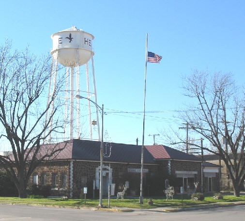
Hearne
|
30
52 48 N / -96 35 49 W
[Hearne City Hall, 3rd
&
Cedar Streets]
Map
"City
Of Hearne. Situated on land originally
granted [1830] to Francisco Ruiz, commander of Fort Tenoxtitlan. The
first first settler, S. Code Brown, operated a tavern, stage stand,
store, and post office which served a large area. Among the southern
planters coming here [1852] were Ebenezer and Horatio Hearne, who later
titled 5,000 acres of land. Mrs. Christopher Columbus Hearne honored
promise of her husband by donating 700 acres to Houston & Texas
Central when the railroad built to this site in 1868. The town, platted
in 1870 and named for the Hearne family, was incorporated in 1871." [#10930/1971] |
Ebenezer Hearne
Cemetery |
30
49 57 N / -96 33 20 W
[5 miles south of Hearne
on Old
Hearne-Bryan Road]
Map
Located
on land owned by David Ely [not open to
public viewing due to difficulty of terrain]. "Located
adjacent to
the former mansion site of "Estate Place Plantation," owned by Ebenezer
and Minerva Walker Hearne, this burial area contains graves of Ebenezer
[1817-69] and Minerva [1815- ?] Hearne, their daughter Icephena Hearne
Dunklin [1849-74] and several children, names not recorded; a landmark
of pioneer days when the Hearne families [1850's settlers] opened
cotton plantations that prospered the area. Home of Horatio Hearne, the
brother of Ebenezer, stood three miles to the south. Memorial plaque
donated by descendants of Ebenezer Hearne." [#10919/1971]
[see Ebenezer Hearne Cemetery] |
|
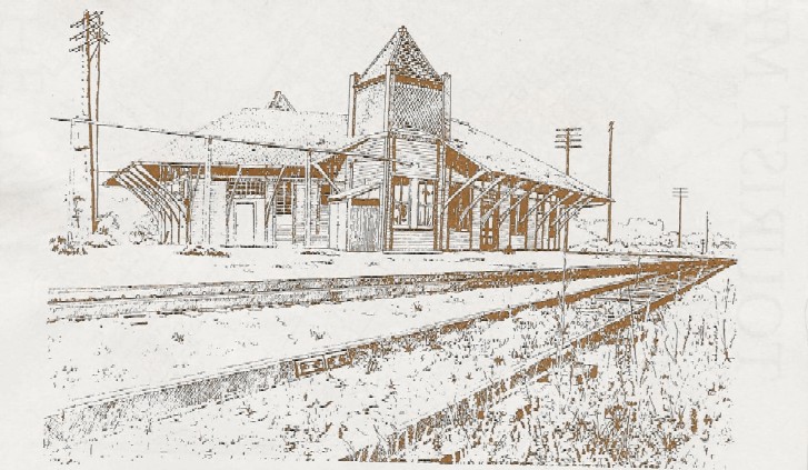
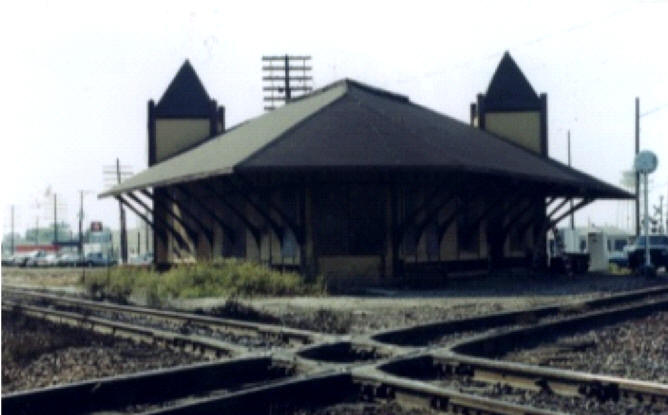
Hearne Depot |
|
|
S. M. Howard
House |
30
58 44 N / -96 40 11 W
[404
Gregg Street, Calvert]
Map
"This
Eastlake style cottage was constructed by
Mrs. S. M. Howard [d. 1932] in 1897, one year after she purchased the
property from her sister-in-law Mrs. E. C. Morse. The home's
outstanding features include fish-scale shingling, a wide veranda with
intricate gingerbread ornamentation, and interior woodwork detailing.
Representative of Calvert at the turn of the century, the house
remained in the Howard family until the 1940s." [#10931/1982] |
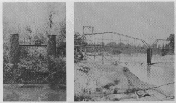
Iron Pillars
Marking
West End
Of Old
Brazos
River Bridge
|
30
43 55.2 N / -96 33 40.5 W
[about
2 miles west of Mumford]
Map
This
marker was placed to the right just before
the railroad tracks past the Mumford School. It has, however, been
vandalized and is now located in the Collier Store awaiting repair and
replacement in a different location across the street.
"An 1895
engineering victory - longest Brazos Bridge in that era - spanning
heavy flow
below ford of 'Little River' [San Andres] with 'Big Brazos'. This
bridge stood
where immemorial Indian trails crossed the river. Later these paths
became part
of the El Camino Real [The King's Highway]. About a mile downstream, in
1830,
Fort Tenoxtitlan was established. In 1855, Jesse Mumford [founder of
Mumford]
operated a ferry at the trail crossing. Authorized by Commissioners
Court of
Robertson County, this landmark iron bridge served until removed by a
flood in
1899." [#?/1968]
|
|
Edward McMillan |
31
02 13 N / -96 21 18 W
[Camp
Creek Cemetery, 8 miles east of
Franklin]
Map
"A
San Jacinto veteran. Born in Ireland, 1814; died
in 1865. His wife, Ann Marjorie McQuistion McMillan; born in Tennessee,
died in 1879." [#10933/1936] |
A Century Of The
Methodist
Church
|
30
52 44N / -96 35 42 W
[408 S. Magnolia Street
[corner
Magnolia & First], Hearne]
Map
"Methodists
of Hearne organized their church
in November 1870 with the Reverend Horace Bishop as pastor. In 1884,
the Reverend Seth Ward became pastor. A church was constructed at this
location in 1885. [Later the Reverend Mr. Ward was the first native
Texan to be a bishop in the Methodist Church.] Through gifts and
pledges of the membership, present edifice was built, 1931; renovated,
1965. Having adopted name "Grace" in 1948, congregation became Grace
United Methodist Church in 1968 and observed 100th anniversary of
Methodism in Hearne in 1970." [#10932/1972]
|
|
Mistrot-Adoue
House |
30
58 51 N / -96 40 23 W
[303
Mitchell Street [Pine & Mitchell Streets],
Calvert]
Map
"This
house was built in the 1870s by Henry B.
Mistrot or Bertrand Adoue. Mistrot was a partner in business with
Adoue's brother Jacques. The two-story residence features
characteristics of the Greek revival and Victorian styles. The French
influence of the owners is reflected in the use of fleur-de-lis
patterns in the woodwork. A prominent area businessman, Jacques Adoue
bought the home in 1888 and it remained in the family until 1977." [#10934/1980] |
|
Mumford |
30
43 55 N / -96 33 40 W
[Mumford
-- Not Yet Placed]
Map
Texas
Historic Marker Pending
|
Nesbitt Cemetery
& Beck
Prairie
Baptist
Church |
31
05 08 N / -96 35 52 W
[8
miles south of Bremond on FM 46, west on CR 127,
Nesbitt]
Map
"Beck
Prairie is believed to have been named after
Tennessee native Absalom Beck, a farmer here in 1850. The name changed
to Nesbitt when postal officials misspelled Nisbett, the name of the
family whose store became the site of the new post office in 1900. In
1875 the Beck Prairie Missionary Baptist Church was organized by
William D. Anderson and B. L. Wright. Its first sanctuary was
built on land donated by Jacob and Elizabeth [Crouch] Anderson in 1878.
Early interments took place in family cemeteries until A. J. Sharp, Sr.
purchased Methodist Church property at this site in 1875 and donated it
to the community for burial and school purposes. The first recorded
burial was that of infant Florence McCrary in 1875. In 1895, Hinnard
Lee and Mary Frances [Murphee] Faulk donated two acres about two mile
Northeast of here to the Beck Prairie Baptist Church. A sanctuary built
at the new location was damaged by storm winds in 1915 and subsequently
repaired. The Beck Prairie Church disbanded in 1956. The church
property was transferred to the Nesbitt Cemetery in 1982. The cemetery,
maintained by descendants of persons buried here, contains veterans of
the Civil War, World Wars I and II, the Korean and Vietnam conflicts."
[#10935/1993] [see Nesbitt/Beck Prairie
Cemetery] |
|
New Baden |
31
03 03 N / -96 25 46 W
Map
"Founded
by German, Prussian, & Swiss
immigrants in 1881, New Baden was named for the German town of
Baden-Baden. The immigrants built a central building known as the
Colony House to provide lodging for families while homes were under
construction. Located on the route of the International & Great
Northern Railroad, the town soon boasted stores, churches, a school,
and a railroad station. Most of the residents were farmers and the
economy was based on agriculture. Population declined in the 1940s, but
New Baden remains a viable rural community." [#11754/1997]
[see New
Baden Collection] |
|
Norwood Cemetery |
30
53 11.0 N / -96 35 18.1 W
[Hearne]
Map
"Though
the oldest known grave on this site was
made for Mary Stroud Bolton in 1870, the year it was deeded to the City
of Hearne, stories persist that patients of the Sisters of Charity
Hospital that once overlooked the cemetery were buried on this site.
Among the nameless may be the Irish and Chinese immigrants who built
the railroad in this region. Other significant burials include those of
Confederate soldier C. W. Gardner and prominent area families Hearne
and Lewis. Norwood Cemetery continues to be the primary burial site for
the city." [#11755/1997]
[see Norwood Cemetery ] |
|
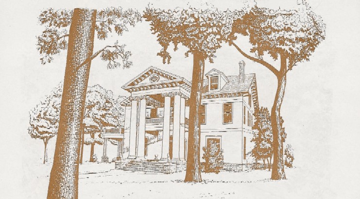
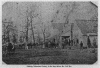
Owensville

|
31 04 23 N / -96 31 09 W
[junction FM 979
& FM 46]
Map
"Site Of
Owensville. Robertson County's third county
seat was located here, 1855 - 1869, on land given by D. H. Love [1816 -
1866]. The town was Owensville, named for Harrison Owen [1803 - 1896],
who was the first county clerk, 1838 - 1847. Public officials, doctors,
lawyers, businesses moved here and town thrived. It was on the
Houston-Waco mail, stage, and freighting road. As Civil War county seat
[1861 - 1865] this place armed and dispatched soldiers and cared for
civilians. After Houston & Texas Central Railway bypassed
Owensville in 1868, county records were moved to Calvert.
Owensville
Cemetery, oldest in the county, marks townsite." [#10936/1974]
[see Owensville] |
|
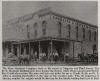
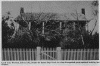
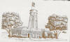
|
Sketch to left from
Owensville Marker Dedication brochure. Color photo to
right by Dr. Habib U. & Martha Jean (Baxter)
Rahman.
Black & white photo to right from
History
Of Robertson County,
p. 133.
|
|
|
The Parish
Carriage House
|
30
58 51 N / -96 40 07 W
[Hanna
& Pin Oak Streets, Calvert]
Map
"In
1892 wealthy merchant, cotton buyer, and banker
L. H. Parish [1846-1924] and his wife Mattie bought this property. Soon
they erected this carriage house with ornate Victorian styling to match
their home. Plans for both structures came from the mail order
catalogue of noted architect George Franklin Barber [1854-1915]. The
first floor was designed to house the bay horses, elegant carriages and
also a tack and feed room. The driver's living quarters were on the
second floor. Incise in base: Sponsored by Walker R. Gray, Jr." [#10937/1980] |
Philen House
[Westbrook-Philen-Byrd Home]
|
30
52 38 N / -96 35 39 W
[604
Magnolia Street, Hearne]
Map
"Built
in 1904 by Jeannie Carr Randle
Westbrook, widow of Colonel Titus C. Westbrook, one of the wealthiest,
most successful planters in Texas with extensive holdings in the Brazos
Valley. Colonel Westbrook purchased the west half of block forty-nine
of the City of Hearne in 1892 shortly before his death. Upon his death
these lots were willed to his brother. Colonel Westbrook's widow
[Jeanne] purchased the lots from his brother in 1894 and purchased the
east half of the block in 1895. The twelve room, three story Colonial
mansion was two years under construction and was completed in 1904.
Jeanne Westbrook died in 1921 in Waco, Texas while attending a meeting
of the Daughters of the Confederacy. Her estate was placed in
receivership and Warren A. Wilkerson was the court appointed receiver.
The house was sold at public auction at the courthouse in Franklin,
Texas on January 3, 1924, to Ellen Hudson, wife of A. G. Hudson, for
$9,000. Slightly more than one month later, Mr. and Mrs. Hudson sold
the house for $9,000 to James Gilbert Philen and wife Mae D. Philen.
Mr. Philen came to Hearne in 1911 and was made cashier of the Planters
and Merchants State Bank. He was made President in 1927 and served in
this capacity until his death in 1949 at the age of 71 years. Mr. and
Mrs. Philen had one child, a son, James Gilbert Philen, Jr. During his
ownership, an elevator was installed to accommodate his wife's mother
who came to live with them in her later years. Mr. and Mrs. Philen had
three grandchildren: Barbara, Joan, and Nancy. In March, 1975, J. G.
Philen, Jr. sold the house to Cecil and Theresa Brooks who made it
their home until July, 1983. The house was then sold to a trust for
Pamela Faulkner. During this time a great deal of reconstruction was
done to the house, including new wiring, plumbing, and central heat and
air were added. In December of 1983, Pamela Faulkner conveyed the house
to the Jupiter Road Baptist Church in Garland, Texas. The church owned
it until May, 1987, when it was sold to Kenneth and Janna Byrd of
Tomball, Texas. Mr. Byrd was born and reared in Houston, Texas, the
seventh child of J. B. Byrd and wife, Thelma. Mr. Byrd's great
grandfather was Ike Byrd of Easterly and his grandfather was Dick Byrd
who lived at Lake Station near Easterly on one of the family farms
until 1921. The family moved to Waller, Texas and finally settled in
Houston. Mrs. Byrd is the daughter of Major [Retired] Jack F. Milstead
and wife, Vera, of Killeen, Texas. Both Mr. and Mrs. Byrd had
grandparents who lived in Robertson County. At the time Mr. and Mrs.
Byrd purchased the house it had fallen into a state of disrepair. It
had remained vacant since 1983 and the reconstruction begun by the
Faulkners was incomplete. The house did not have a kitchen and there
were no bathrooms on the second floor. In 1984, the water pipes had
frozen and burst. The house suffered extensive water damage. Mr. and
Mrs. Byrd began to repair the damage and complete the reconstruction
begun by the Faulkners. Mr. and Mrs. Byrd moved into the guest house in
January of 1990 while the repairs were being completed and began living
in the main house in December, 1990."
Marker doesn't have
an inscription; text taken from a brochure provided by Mrs. Byrd.
[#10940/1962] |
|
Randolph-Field
Place |
30
58 47 N / -96 40 07 W
[800
China Street, Calvert]
Map
"One
of Calvert's earliest houses, Greek Revival in
style. Built about 1871 by George F. Randolph, local merchant, said to
have been a kinsman of U. S. President Thomas Jefferson. Randolph and
his bride, Lucy Garrett, lived here until he died in 1873 yellow fever
epidemic. The widow married [1878] Scott Field, a rising statesman who
in 1887-91 was a United States Congressman. House remained in the Field
family until 1941." [#10938/1970] |
|
Captain Henry Reed |
31
01 18 N / -96 36 02 W
[Mount Vernon
Cemetery, 6 miles east of
Calvert]
Map
"Participated
in the Battle of San Jacinto and
later in 1836 commanded a volunteer company. Born in Tennessee November
10, 1800; died November 11, 1854." [#10939/1936] |
|
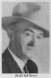
Sheriff Bob Reeves |
31
00 57 N / -96 28 54 W
[Franklin Cemetery]
Map
"Born at Ridge,
Texas, served 1937 - 1951 as Sheriff
of Robertson County
and attracted statewide notice when he directed the 1947 capture of a
bank
robber. He and his wife Oda had two children: Imogene and Bob, Jr." [#10941/1968] |
|
|
|
Robertson County
|
31 02 11 N / -96 28 00 W
[roadside park
between Franklin & New Baden,
near the extinct Englewood community site]
Map
"Settled by
people of Tennessee under an 1822
contract held by Sterling
Clack Robertson [1785 - 1842] who later signed the Texas Declaration of
Independence. Colony and county were named for him. County was created
December
14, 1837; organized March, 1838. County seats: Old Franklin 1838 -
1850; Wheelock, 1850 - 1855; Owensville, 1855 - 1869; Calvert, 1870 -
1879; Franklin,
since 1879. Sent five troop companies into Confederate service in Civil
War.
Established mill to make flour, cotton, and wool cloth. Furnished
cotton, cards,
medicines, bacon, and salt to soldiers' families."
[#10942/1965] |

|
|
|
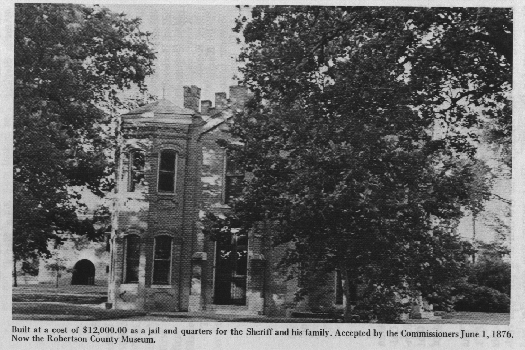
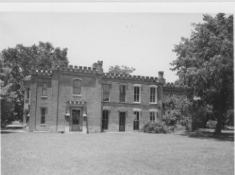
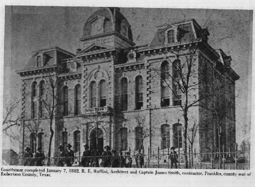
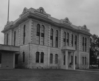
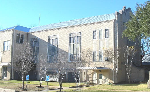
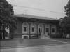
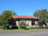
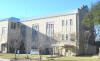
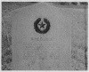
Robertson County
Courthouse
|
31 01 36 N / -96 29 14 W
[Franklin]
Map
(see photos above)
"Erected in 1882
at a cost of $30,000, this white
limestone building is
the fourth to serve as Robertson County Courthouse. In 1879 the county
seat had
been moved for the fifth time to Morgan, on the International &
Great
Northern Railroad. But because Texas already had a post office named
Morgan, the
town was renamed Franklin for the first county seat, which was named
for pioneer
Will Franklin. Plans for a courthouse were begun that year and in 1881
the
construction was started under F. E. Ruffini, Architect. Since then the
building
has been remodeled."
[#10943/1968] |
|
Sneed Memorial
Methodist
Church

|
30
58 50 N / -96 40 20 W
[Beech
& Mitchell Streets, Calvert]
Map
"This
congregation, organized in 1869 as the
Calvert Methodist Church, built its first sanctuary on this site in
1872. Among the early pastors were [1885 - 1886] the Reverend Seth
Ward, later first native Texan to be named a Methodist bishop; and
[1895 - 1899] the Reverend Dr. James Kilgore, a founder of Southern
Methodist University. In 1923 when the present church building was
erected, the name was changed in memory of the Reverend Joseph Perkins
Sneed [1804 - 1881], a circuit rider who came to Texas in 1838, then
served for many years in Robertson and Milam County churches." [#10947/1975]
|
Saint Paul
Methodist
Church |
30
58 51 N / -96 40 45 W
[101
Pecan Street [corner Pecan & Hwy. 979],
Calvert]
Map
"This
congregation organized in 1872 as St. Paul Methodist Episcopal Church,
North. After their first church building burned, members of St. Paul
moved quickly to replace it. Using salvageable material from the old
sanctuary as well as new materials, noted area carpenter and church
member Charlie Terrill completed this building in 1900. Since that time
it has served as a place of worship for the congregation and as a
center for community activities. Members hosted the West Texas Annual
Methodist Conference here in 1913. A fine example of the Gothic Revival
style, St. Paul church features a central tower, pointed-arch windows
and fish-scale shingles on the gables." [#12590/2001] |
|
Spikner High
School |
30 58 18
N / -96 40 50 W
[Calvert -- Not Yet Placed]
Map
Texas
Historic Marker Pending
|
St. Mary's
Catholic
Church |
31 10 18 N / -96 40 19 W
[800 N. Main
Street [Corner FM 2954 & FM 2413],
Bremond]
Map
New
church building cornerstone dated 1971;
building described on marker no longer exists. "Founded
1876 to
serve Poles settling in Bremond that decade. First church built 1879.
Since 1908 [date of this edifice] has been parish school. Fathers A.
Krypajtis [died 1907] and I. J. Szymanski [died 1941] led building of
this Gothic structure. Parish made sacrifices, gave much labor to
create edifice of old world charm. Font and sacred art came from the
1879 structure. Settlers and heirs come yearly from far away to worship
here." [#10944/1969] [see Polish
Collection] |
|
|
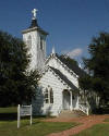
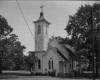
St. Philips
Episcopal
Church

|
30 52 42 N / -96 35 45 W
[408 Cedar Street
[corner First & Cedar], Hearne]
Map
"W. B. Wadsworth
[1843 - 1916] and J. G. Wilkerson
[1847 - 1903] moved their families to the Hearne area from Matagorda.
With their help, this church was founded in 1871. It was named in honor
of the Reverend J. W. Philips who preached the first sermon. This
property was donated to the congregation by the New York &
Texas
Land Company. Services were conducted in a wooden church building until
the present Gothic Revival structure was completed in 1912." [#10945/1979]
|
 |
|
|
Staggers Point |
30
45 20.7 N / -96 27 03.9 W
[1
mile east of Hwy 6 at Benchley on Old San
Antonio Road; beside El Camino Real marker]
Map
"Earliest
large community in Robertson's colony.
Settled by Irishmen who came to America in 1821; lived in South
Carolina and then in Alabama; and in 1829 sent west an emissary, Robert
Henry, to find a permanent location. In 1833, their ox-wagon train
arrived, and log cabins were built. By 1836, kinsmen had joined early
arrivals to strengthen settlement. Community name, meaning "Strivers'
Point" in dialect, was probably given for rugged zeal of settlers in
face of hardships. James Dunn built a fort, to give neighborhood a
refuge during Indian raids. In War for Independence, 1835-36, Staggers
Point men fought in major actions, including the April 21, 1836, Battle
of San Jacinto, which freed Texas from Mexico. In 1830s and 40s, the
Irish were compelled to keep up their defenses against the Indians.
Women as well as men earned respect for skill with "long guns." In time
their village had a church, stores, cotton gin, race track, and
taverns, and was invaded by gamblers and ruffians drawn to the races.
Until the settlers subdued the lawless, duels and gunplay were common.
This remained a progressive community until 1868, when Houston
&
Texas Central Railway bypassed it, and business waned. Descendants
still honor the settlers. Original settlers: William Henry, Mary F.
Henry Dixon, James M. Dixon, Ann McMillan, Henry & Sarah
Fullerton,
Robert & Elizabeth Henry, George H. Fullerton, John R.
& Sarah
Peyton, Jimnive Henry Rice, William Fullerton, Hugh & Elizabeth
Henry, James A. Henry, Bradford & Mary Henry Seale, Columbus
&
Elizabeth Henry Seale, James & Isabella Dunn" [#10948/1973] |
|
Isaac Phillip
Stem |
31
14 57 N / -96 25 13 W
[Wesley Chapel
Cemetery, 16 miles north of
Franklin on FM 979, north of Bald
Prairie]
Map
"Tennessee
native Isaac Phillip Stem enlisted in
Western Frontier service in that state in 1836. In October 1836, he
moved to Texas and joined the Republic of Texas Army at Houston.
Continuing to serve in the military, Stem was a participant in the
Battle of Plum Creek on 8.12.1840, in present Caldwell County. The
battle was fought between Texas soldiers and Comanche Indians, who had
raided the coastal towns of Linnville and Victoria. Stem served in the
Somervell Campaign of 1841 and was a member of a cavalry of mounted
volunteers during the Mexican War. After his discharge from the Texas
troops in 1846, Stem joined the US Infantry at Corpus Christi, Texas
and continued in the war with Mexico. Discharged at Monterey due to
illness, he later returned to Tennessee and joined the Tennessee
Volunteers at Memphis. He later transferred into the US Infantry once
again. Isaac Phillip Stem and his wife, Lucy Ann Weaks, were the
parents of eight children. The family moved to Robertson County in 1869
and Stem became a farmer and rancher. He died in 1893 and was buried
here beside his wife." [#10949/1988] |
|
Sterling Cemetery
|
30
59 05 N / -96 42 26 W
[two miles west of
Calvert on FM 979 to CR 116]
Map
This
cemetery is on private property and is not easily
accessible. A fenced-in area is visible from the road where a handful
of tombstones remain. This is only a small portion of the cemetery.
Other markers can be found on several acres in the surrounding fields
which are now somebody's pasture. "Burial
place of some 400 Texas
pioneers and descendants. On land granted [1835] to A. J. Webb; bought
in 1850 by Judge Robert Calvert, a civic leader in Sterling, a town
named for empresario Sterling C. Robertson. Calvert dedicated 11.1-acre
cemetery and built adjacent Cumberland Presbyterian Church of his own
plantation timber. In 1867, Judge Calvert died and was buried near
cemetery gate. The church building was moved by oxen to new town of
Calvert [2 mi. E]. In 1868, his wife, Mary Keesee Calvert, and their
three daughters deeded cemetery site to the Cumberland Presbyterians." [#10950/1973]
[see Sterling
Cemetery] |
|
Stricker-Sneed
House

|
30
58 57 N / -96 40 12 W
[503
Pin Oak Street, Calvert]
Map
"Victorian
house built in 1900 by Herman L. and
Katy Stricker, business, civic, social leaders. Stricker was a jeweler;
his wife, daughter of Confederate General William H. Hamman. Mrs.
Stricker led in movement to erect League of Women's meeting house, now
the Calvert Library building. In 1913, banker H. Marvin Sneed and his
wife Cara [Weber] bought the house; their heirs sold it to Mr. and Mrs.
Kimbrough Gray, 1970." [#10951/1973]
[see Pin
Oak Bed & Breakfast] |
|
Suggs Cemetery |
30
52 53 N / -96 31 59 W
[4
miles east of Hearne on FM 391, south on county
road, Black Jack]
Map
"Calvin
A. Suggs and his family came to Texas from
Georgia in the late 1860s. They settled in this area about 1868 and
Suggs purchased 80 acres of land. This cemetery was established on
Suggs' land and has served as the principal burial ground for the Black
Jack community for over a century. The oldest documented grave here is
that of Jera William McWilliams who died on October 11, 1880. Many
pioneer settlers of this area are interred in the Suggs Cemetery in
marked and unmarked graves. It serves as a reminder of the area's early
heritage." [#10952/1989]
[see Suggs
Cemetery] |
|
Thompson Cemetery |
31
15 01 N / -96 23 51 W
[2.5
miles north of Bald Prairie on FM 979 to CR
478]
Map
“A
native of North
Carolina, Benjamin Rush Thompson [1811 – 1880] migrated to
Milam
County in the Republic of Texas in 1841. Thompson was a Mason and
according to the census of 1850 a Methodist clergyman. He moved his
family to Robertson County after 1855. Thompson set aside a portion of
his land as a family burial ground in 1873, after the death of his son
William M. [b 1852]. Only five of the thirteen graves are marked with
inscribed stones. Thompson and his wife Margaret [1819 –
1880]
are both buried here.” [#10953/1985] [see
Thompson Cemetery] |

Virginia Field
Park

|
30
58 59 N / -96 40 08 W
[Burnett
Street between Pin Oak & Maple,
Calvert]
Map
"Land
given to Calvert 1868 for use as a park by
the Houston & Texas Central Railroad. Co C. 4th Texas Infantry
Regiment, Hood's Texas Brigade, under Major William Townsend, mustered
nearby in 1865. Was site during Reconstruction, 1868 - 1873, of 'Sky
Parlor' [room built on pole, as a tree house] to serve as prison for
Southern sympathizers. In 1895 and 1912, Hood's Texas Brigade
Association entertained here. The Victorian pavilion and two gazebos
were built 1895 for concerts, gatherings, and dancing. The park was
named in 1937 for landscaper, Mrs. Virginia Field." [#10954/1968] |
|
Walnut Creek
Cemetery |
31
10 56 N / -96 36 27 W
[7
miles east of Bremond on FM 2293 to
Redbank Creek Road]
Map
"The
Walnut Creek community was established in the
1850s with the arrival of several farming families. J. Grant Taylor
came as a child to this area with his parents. Tradition says the
Walnut Creek Cemetery began before 1869 with the death of a
two-year-old girl. She was the daughter of a horse trader who lived
nearby. Taylor gave permission for the child's burial on his 30-acre
tract of land. The unmarked grave is at this site under a cedar tree.
The first marked grave is located under the same cedar tree and is that
of Sarah Lane Johnson [1866-1869], daughter of P. and S. H. Johnson.
About 1871 Taylor donated two acres for a burial ground, Union
meetinghouse, and school building. Since area students attended Stump
Toe School [3 mi. N], a structure was not built here until 1888.
Baptist, Church of Christ, and Methodist congregations held services
here, constructing brush arbors on the grounds in the summers. Classes
were held in the school building until World War II when Walnut Creek
consolidated with Bremond schools. Afterward, the schoolhouse was used
for annual memorial services. This cemetery is all that remains to mark
the Walnut Creek community." [#10955/1979]
[see Walnut
Cemetery] |
|
Wheelock
|
30
53 58 N / -96 23 32 W
[State
& High Streets, FM 391 & FM 46]
Map
"Founded
in 1833 by
Colonel Eleazar Louis Ripley Wheelock, soldier, lawyer, and educator.
One of the organizers
of Robertson's Colony. Captain of Texas Rangers. Died in Edwardsville,
Illinois
in 1846 while visiting the place of his birth."
[#10956/1936]
[see Wheelock
- Texas State Cemetery]
|
|
Wheelock |
30
53 59 N / -96 23 34 W
Map
"Eleazar
Louis Ripley Wheelock [1793 - 1847] came
to Texas from Illinois in 1830. A surveyor for Robertson's Colony, he
established a town on his land along the Old San Antonio Road. Named
Wheelock in 1837, the town boasted twenty businesses by the 1840s,
including general stores, land and freight offices, and a cotton gin.
By 1845 Wheelock was a transportation hub in central Texas. A post
office was established in 1846, and the town was Robertson County seat
from 1850 to 1856. Bypassed by the railroad in the 1860s, Wheelock
declined; many of its citizens moved to Hearne." [#11756/1997]
[see Wheelock
- Texas State Cemetery] |
General Walter
Washington
Williams |
31
01 22 N / -96 25 23 W
Map
[Mount
Pleasant
Cemetery, 4 miles east of
Franklin on FM 2466]
"Reputed
to have been last surviving
soldier of the Civil War [1861-1865]. Born in Ittawamba County, Miss.,
Williams [Nov. 14, 1842 - Dec. 19, 1959] during the war was a forage
master for the celebrated Hood's Texas Brigade. Soon after the war he
moved to Texas and farmed near here. He was twice married and had a
large family, with descendants numbering over 200 when he died. He had
lived very quietly until in extreme old age he gained fame as one of a
very few remaining veterans. After the nation lost all other men who
had fought in the Civil War, he was given honorary rank of General by
President Dwight D. Eisenhower. When General Williams died in Houston
at home of a daughter, President Eisenhower proclaimed a period of
national mourning. Williams rests here in Mount Pleasant Cemetery among
families who migrated to Texas and braved the dangers of the frontier
for years before he came. This is one of the oldest public burial
grounds in Robertson County, situated within boundaries of colony
planned north of El Camino Real by the pioneer Sterling C. Robertson,
from Tennessee. The Robertson Colony was founded in the 1820s and was a
major civilizing influence in East Texas." [#10957/1970]
|
|
Wootan Wells |
31
08 17 N / -96 43 11 W
[Hwy.
6 & FM 1373, 2.5 miles west of Bremond]
Map
"Famous
early
health spa and resort. First well was dug 1878 by landowner Francis
Wootan.
Water tasted good, but turned dishes yellow and clothes red. Even so,
it seemed
to possess amazing curative properties. Wootan soon built a hotel and
in 1879 a
resort town made its debut. He formed a promotion company with T. W.
Wade and
more hotels, a bottling works, dance pavilion, and school sprang up.
Leading
socialites came from miles to 'take the waters'. Disaster struck in
1915 when
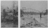
fire swept the town. In 1921 the last buildings also burned." [#10958/1969]
[see Wootan Wells Collection]
|